The WWF is run at a local level by the following offices...
- WWF Global
- Adria
- Argentina
- Armenia
- AsiaPacific
- Australia
- Austria
- Azerbaijan
- Belgium
- Bhutan
- Bolivia
- Borneo
- Brazil
- Bulgaria
- Cambodia
- Cameroon
- Canada
- Caucasus
- Central African Republic
- Central America
- Central Asia
- Chile
- China
- Colombia
- Croatia
- Democratic Republic of the Congo
- Denmark
- Ecuador
- European Policy Office
- Finland
Every time a green field becomes a concrete plaza, or a tree-lined street is replaced by a flyover, we lose something far more valuable than landscape. We lose nature’s own air-conditioning system. And the evidence, drawn from 25 years of satellite data over Lahore District, is now impossible to ignore.
The Urban Heat Problem
Urbanization — the rapid conversion of natural land into cities, roads, and buildings, is one of the most powerful drivers of local climate change. As vegetation disappears, it is replaced by concrete, asphalt, and rooftops that absorb heat during the day and release it slowly at night. The result is what scientists call the Urban Heat Island effect: cities become significantly hotter than the rural or green areas surrounding them. For residents of cities like Lahore, this is not a distant theory — it is an existing reality.
What 25 Years of Data Tells Us
WWF-Pakistan analyzed nighttime Land Surface Temperature (LST) data from NASA’s MODIS satellite for Lahore District from 2001 to 2025. The findings are stark:
• Vegetated areas (parks, farms, green corridors) warmed up by +2.16°C over 25 years.
• Non-vegetated, built-up areas warmed by +3.07°C - nearly 42% faster.
• The temperature gap between green and built-up surfaces has grown from 0.25°C in 2001 to 1.16°C in 2025 - and is still widening.

Nighttime temperatures tell the real story. In natural, green areas, the ground cools down once the sun sets, releasing moisture and letting the air breathe. But concrete and asphalt work differently. They soak up heat all day and keep releasing it through the night, like a furnace that never fully switches off. There is no real cool-down, no relief.
This effect is most dangerous in May when Pakistan's most brutal pre-monsoon month. In Lahore's most built-up areas, temperatures have been creeping up by 0.20°C every single year. That may sound small, but over 25 years it adds up to nearly 5°C of extra nighttime heat, in a city that already experiences dangerous levels of heat stress.
May: Lahore’s Most Hazardous Month

May marks the peak of Pakistan's pre-monsoon heat season when temperatures spike sharply before monsoon relief finally arrives. The hotspots are not scattered randomly. They cluster consistently in areas with the least vegetation, dense commercial zones, industrial corridors, and rapidly expanding urban peripheries where farmland has been swallowed by development. Meanwhile, areas that retain tree cover and agricultural land show markedly lower warming rates, confirming that the problem is not just climate change, it is the choices being made about land.
The Human Cost of Losing Green Spaces
This is not just an environmental issue but rather is a public health crisis unfolding in slow motion. Hotter nights mean the human body cannot fully recover from daytime heat stress. For outdoor laborers, the elderly, children, and the millions of Pakistani families without access to air conditioning, every degree of warming is a direct threat to health, sleep, and survival.
The 2022 Punjab heatwave while being one of the most severe in recorded history, exposed just how vulnerable Pakistan’s urban populations already are. What was then an emergency is becoming a recurring condition. And as cities continue to grow without adequate green space, the frequency and intensity of such events will only increase.
There is also an energy dimension. As temperatures rise, electricity demand for cooling surges, pushing an already strained grid to its limits, driving up costs for households, and generating yet more waste heat that feeds back into the urban environment. It is a vicious cycle, and it is accelerating.
Nature Is the Solution
The good news is that the same data pointing to the problem also points clearly to the solution. Vegetation works. It cools. It buffers. It protects. And it does so passively, reliably, and at scale, without a power bill.
Urban greening through tree planting, green roofs, parks, roadside vegetation, and the protection of peri-urban farmland, is among the most cost-effective climate adaptation strategies available to city planners today. These are not luxury additions to city design. They are essential infrastructure, as critical as roads or drainage systems.
As Lahore and cities across Pakistan continue to grow, the question is not whether to develop but how, and at what cost to the natural systems that keep us alive. Every hectare of green space preserved today is a gift of cooler nights and safer summers to the next generation. Every hectare lost is a debt they will pay in heat, health, and hardship.
“Protecting and restoring urban vegetation is no longer optional, it is one of the most critical steps we can take to cool our cities and protect our communities.”
Authors: Usama Maqsood & Usman Akram | Richard Garstang Conservation GIS Lab | WW-Pakistan

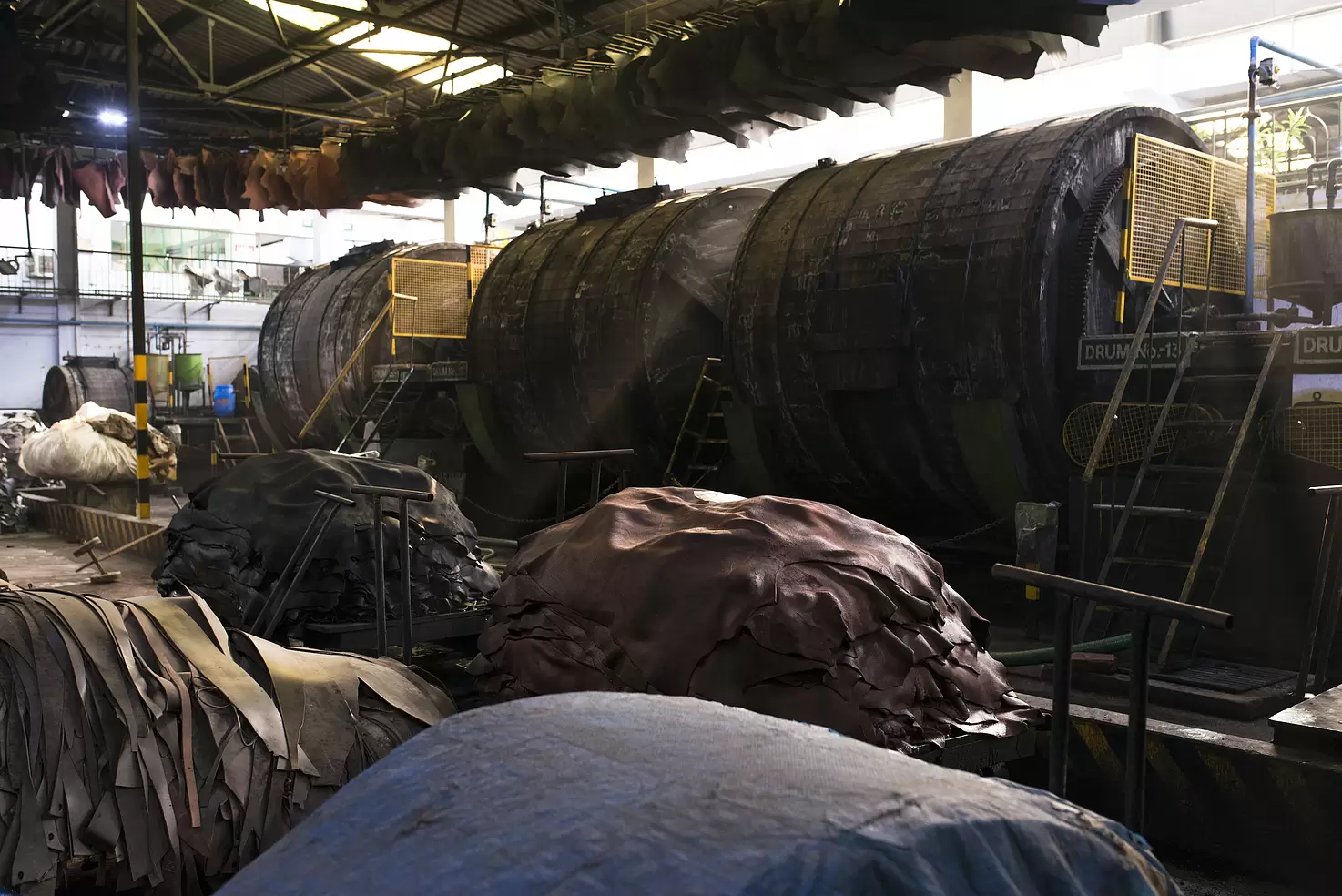
From rural livestock farms to booming tanneries and global fashion brands, every piece of leather carries the imprint of choices made along its journey. It is essential that these choices respect people, animals, and the planet.
The leather sector contributes almost 4% to the GDP of Pakistan through its export. However, increasing global focus on environmental protection, labour rights, and transparency has made sustainability a critical lever for ensuring long-term global competitiveness. To do so, Pakistan’s leather sector, which is traditionally labour and resource intensive, needs a paradigm shift to meet the needs of global consumers and overall sustainability goals.
In Pakistan, leather is sourced as a by-product of the meat industry, which means that animals are not raised for leather production. Building on this foundation, ethical leather sourcing promotes responsible livestock management that respects animal welfare, avoids deforestation, and minimizes environmental degradation. It also requires decent working conditions that protect workers from hazardous chemical exposure and eliminate unsafe practices across the value chain.
Ethical sourcing is a cornerstone of sustainability in leather manufacturing. Tanneries that adopt responsible sourcing practices are better positioned to implement cleaner production methods, reducing their environmental footprint. One of the most pressing challenges in leather processing is the use of toxic chemicals, coupled with inadequate wastewater treatment, which poses serious risks to rivers, ecosystems, and the communities that depend on them. Today’s consumers want to know who made their products and how. Ethical sourcing answers this concern by introducing traceability systems, certifications, and disclosure mechanisms that build trust. Detailed documentation of suppliers, sourcing methods, and environmental practices; open communication between buyers and suppliers regarding lifecycle impacts; third-party audits to ensure credibility; and digital traceability systems to track leather origins and processing stages are some of the best practices to ensure ethical sourcing.
Ethical leather sourcing supports sustainability across social, environmental, and economic dimensions. From a social perspective, it reduces the risks of child and forced labour, improves workplace safety and inclusivity and ensures fair wages. This is particularly important for women, who often occupy low-paid, under-recognized roles across the value chain. Ethical sourcing practices also limit workers’ health impacts from exposure to hazardous chemicals. Environmentally, it encourages responsible animal welfare practices, improves wastewater treatment and pollution control, and reduces excessive chemical usage throughout the production process. Economically, ethical sourcing lowers legal and
reputational risks, enhances access to international markets, and strengthens the long-term competitiveness of leather enterprises.
Despite its benefits, small and medium tanneries face challenges such as high costs of eco-friendly chemicals, wastewater treatment infrastructure, and limited awareness of global sustainability requirements. Under the project ‘Pakistan Leather Sector: Traceability, Cleaner Production and Circularity,’ funded by UK International Development through SMEP programme, WWF-Pakistan addresses these barriers through capacity building and technical guidance of the leather related stakeholders for a smooth and gradual transition.
Ethical leather sourcing is a robust entry point for achieving sustainable leather supply chains in Pakistan. By strengthening traceability, improving chemical management, and supporting responsible manufacturing, it is important for the leather industry to align with global sustainability expectations while enhancing environmental protection and economic resilience.
Javeria Latif, SMEP Intern, Freshwater Programme, WWF-Pakistan
Climate change is often discussed through rising air temperatures and extreme heat at the surface. For marine turtles, this raises a critical concern: are nesting beaches becoming too warm for successful incubation? Headlines and climate summaries suggest increasing risk, but they rarely tell us what is happening where it matters most — beneath the sand, inside the nest.
Looking beneath the sand surface, what does a turtle nest really experience?
At Hawks Bay, one of Pakistan’s most important Green turtle (Chelonia mydas) nesting beaches, a temperature logger was placed inside a single Green turtle nest at a depth of approximately three feet (~0.9 m). Hawks Bay is not formally designated under regional frameworks, but it remains ecologically significant and supports regular nesting activity along Pakistan’s coast.
For 17 consecutive days, nest temperature was recorded every two hours, day and night. These nest measurements were paired with ERA5 climate reanalysis data, using both 2-metre air temperature and surface (skin) temperature — the latter serving as a proxy for sand surface heating. This pairing allowed a direct comparison between what climate records suggest and what turtle embryos actually experience underground inside the nest.
Does the nest feel the heat the way the surface does?
The answer is clear: No.
Figure 1 presents the full sub-daily temperature time series for the nest alongside ERA5 air and surface temperature. While the air temperature fluctuates rapidly and surface temperature shows sharp daytime peaks, nest temperature behaves very differently. It changes more slowly, shows a delayed response to external conditions, and remains far more stable overall.
This difference matters. Why? Because embryos’ development depends on the temperature inside the nest. Embryos do not respond to surface heat spikes or air temperature extremes; they respond to the thermal environment inside the nest. Assessing climate risk using surface metrics alone risks overstating the threat while missing the buffering role of the sand itself.

Figure 1: Figure 1. Sub-daily nest temperature compared with ERA5 air and surface (skin) temperatures.
Day and night tell different stories
When the data were separated into daytime and nighttime periods, another clear pattern emerged. At night, the nest remained warmer than the surrounding air, retaining heat as surface sands cooled. During the day, the opposite occurred: the nest remained cooler than the sand surface, even during the hottest conditions.
The pattern highlights the role of subsurface thermal inertia - the ability of sand to buffer both rapid heating and rapid cooling, and sand depth acts like a thermal stabilizer.

Figure 2A: Day vs night sub-daily time series showing nest temperature (~0.9 m depth) alongside ERA5 air and ERA5 skin temperature.
How strong is this natural thermal buffering?
To test whether nests are vulnerable during extreme heat, we focused specifically on periods when surface temperature exceeded the warmest 25 per cent of observations. These conditions represent the most challenging thermal environment embryos might face.
Even under these extremes, the nest remained, on average, around 9°C cooler than the surface. This substantial difference confirms that sand depth provides powerful thermal buffering, effectively shielding turtle embryos from the hottest surface conditions.
 Figure 3: Mean and median differences between nest temperature and ERA5 skin temperature during the warmest 25% of surface conditions.
Are embryos experiencing thermal stress at the biological threshold?
Marine turtle embryos typically experience stress at sustained temperatures above 33–35°C, commonly cited incubation stress thresholds. Across all two-hourly nest observations in this study, the maximum temperature recorded was approximately 26.5°C. Not a single observation approached known stress thresholds.
Is there hidden cumulative heat exposure?
Thermal stress does not only come from short spikes; prolonged exposure over several days can also be harmful. To examine this risk, rolling averages were calculated over 24, 72, and 120-hour windows.
Even at these longer timescales, maximum rolling mean nest temperatures remained below 25.3°C, showing no evidence of cumulative heat build-up approaching biological risky levels. In other words, the nest was protected not only from extreme peaks but also from sustained warming.
What happens under future warming?
The next question is unavoidable: what if the climate warms further?
To explore this, uniform warming scenarios of +1°C to +4°C were applied to every sub-daily nest observation. Even under the most extreme conditions ( +4°C), there was zero exceedance of known stress thresholds, and minimum safety margins remained at or above roughly 2.5°C.
What does this tell us about nature’s role?
This analysis is based on a single nest and does not claim universal outcomes. While this finding is based on site-specific evidence and does not constitute formal IUCN NbS Standard verification, it demonstrates clear technical alignment with NbS principles by showing how intact coastal ecosystems can deliver measurable climate-adaptation benefits through natural processes, deliver measurable biophysical benefits, and support biodiversity without engineered intervention. This natural phenomenon could be adopted as a NbS intervention for degraded coastal regions.
At Hawks Bay, natural sand depth and beach structure dampen thermal extremes, prevent acute and cumulative heat stress, and provide resilience without engineering intervention. These processes operate quietly, continuously, and at no cost – as long as beach morphology remains intact.
Key takeaways
Nest temperatures were far more stable than air or surface temperatures, even during extreme heat. Natural sand depth provided strong thermal buffering, keeping nests well below biological stress thresholds. No short-term spikes or cumulative heat exposure were detected, and even future warming scenarios did not eliminate safety margins. Healthy beaches already protect turtle embryos from climate heat.
What this means for policy in Pakistan
These findings have direct relevance for Pakistan’s climate and biodiversity commitments. Intact turtle nesting beaches should be recognised as valuable climate adaptation assets under national climate planning. Conservation strategies should prioritise protecting beach morphology – sand depth, natural profiles, and reduced disturbance – rather than relying on costly interventions such as shading, watering or nest relocation.
Well-managed nesting beaches also meet the criteria for Other Effective Area-Based Conservation Measures (OECMs), contributing to Pakistan’s commitments under the CBD Global Biodiversity Framework, including the 30x30 target. Expanding low-cost nest-scale monitoring can further strengthen evidence-based coastal management and climate resilience planning.
The final thought
Climate change poses real risks to marine turtles. Yet this study offers cautious optimism. When beaches remain intact, nature provides resilience – quietly, effectively and without engineering.
Protecting that resilience may be one of the most powerful climate actions available for marine turtle conservation.
About the author:
Shoaib Abdul Razzaque is the Focal Point at WWF-Pakistan. He is also the Vice Chair and NGO Focal Point for Pakistan to the CMS–IOSEA Northern Indian Ocean Marine Turtle Task Force (NIO-MTTF).
Mangroves are some of the world’s most vital yet underappreciated ecosystems. Found at the intersection of land and sea, they serve as natural shields, buffering coastlines from storms, preventing erosion, supporting rich biodiversity, and sequestering significant amounts of atmospheric carbon. Despite covering less than 1% of tropical forests globally, mangroves store up to four times more carbon per hectare than inland rainforests (UNEP, 2020).
In Pakistan, the Indus Delta spans over 130,000 hectares of mangrove forest (WWF-Pakistan, 2021), dominated by Avicennia marina. It forms the largest arid mangrove ecosystem in the world and ranks among the top six largest mangrove systems in Asia (UNEP-WCMC, 2021). These forests support fisheries, absorb pollutants, and stabilize shorelines along Sindh and Balochistan.
As these silent guardians protect millions of lives and coastal assets, they face mounting pressures. Industrial discharge, untreated sewage, urban encroachment, shrinking freshwater flows, and rising sea levels are all pushing mangrove health to the brink (IUCN, 2017). Although ambitious reforestation efforts under the Ten Billion Tree Tsunami Programme have led to a tenfold increase in national mangrove cover since the 1990s (Government of Pakistan, 2022), many patches still suffer from poor regeneration, high salinity, or fragmentation.
This degradation doesn’t just threaten nature, it directly affects the 135,000+ coastal households in Pakistan whose livelihoods depend on fishing, fuelwood, fodder, and natural storm protection.
The Role of Technology in Conservation
A new generation of tools is transforming how mangrove health is monitored. Traditional field surveys—while critical—are expensive, time-consuming, and often limited in scope. But thanks to satellite remote sensing and platforms like Google Earth Engine (GEE), we can now monitor thousands of square kilometres with a few lines of code and a reliable internet connection.
Publicly available imagery from satellites like Landsat (since 1972) and Sentinel-2 (since 2015) allows researchers to observe coastal forest dynamics with high frequency and spatial precision. Through spectral vegetation indices such as the Normalized Difference Vegetation Index (NDVI) and Mangrove Vegetation Index (MVI), we can estimate plant health, canopy cover, and regrowth patterns using light reflectance data, —without setting foot on the ground.
These insights are critical for spotting early degradation, locating regrowth hotspots, and prioritizing restoration zones—particularly in areas threatened by cyclones, salinity intrusion, or unregulated coastal development.
Remote Sensing of Mangrove Ecosystems: A Student-Led Case Study
In our final year project, we used satellite-based remote sensing to monitor mangrove health along Hawkes Bay. Sentinel-2 imagery from 2024 to 2025 helped us generate NDVI and MVI maps to track seasonal changes in vegetation.
Our analysis (Figure 1) shows that NDVI values peaked during December (0.41)—the winter season—when cooler temperatures and reduced evapotranspiration supported optimal vegetation health. MVI values also reached their highest point in December (5.61), indicating dense mangrove coverage.
Post-monsoon months, particularly October (0.41) and November (0.39), also recorded relatively high NDVI values, suggesting recovery after the monsoon season. Conversely, the lowest NDVI values were recorded in May (0.22) and June (0.28), reflecting heat stress and reduced water availability during the pre-monsoon and early monsoon periods. MVI values followed a similar trend, with the lowest readings in May (2.19), highlighting reduced canopy density during the hottest months.

Figure 1: Seasonal trend of Mean NDVI and Mean MVI for Hawkes Bay (2024–2025)
This seasonal variability underlines the importance of long-term monitoring, as a single observation period may not reflect the full ecological dynamics of the mangrove ecosystem. For example, while MVI indicates where mangrove density is high, NDVI reveals whether that density is associated with healthy vegetation. In 2024–2025, WWF restoration plots planted in 2020 continued to show positive MVI signals, but NDVI readings revealed that some areas of high density were still stressed due to salinity intrusion and climatic extremes.
We also used field GPS points and community interviews to validate these satellite observations, improving the accuracy of our classification model and providing a more nuanced understanding of actual versus perceived forest recovery.
Change Detection Analysis (2020 vs. 2024)
To assess long-term changes, we compared NDVI and MVI for 2020 and 2024 (Figure 2).
The MVI maps show that mangrove density remained relatively high in most parts of Hawkes Bay between 2020 and 2024, with dense coverage visible in restored zones. However, some localized areas showed slight reductions, possibly linked to tidal erosion or cutting pressure.
The NDVI maps reveal a more nuanced story. While canopy density remained stable in many areas, vegetation health (as measured by NDVI) declined in several inland patches. This suggests that while the mangrove trees are present, they may be under environmental stress—likely due to salinity intrusion, restricted freshwater inflows, or climatic extremes.

Figure 2: Comparison of MVI (left) and NDVI (right) for Hawkes Bay in 2020 and 2024
This highlights the critical lesson that density alone does not equate to ecosystem health. Continuous monitoring using both MVI and NDVI helps identify not just where mangroves are present, but whether they are thriving.
From Pixels to Policy: Ground Truthing & Restoration
While satellite tools give us a bird’s-eye view, ground-truthing is still vital. Local field teams verify what satellites observe by checking soil salinity, plant height, and species mix on the ground—linking “what we see from space” to “what’s happening on the ground.”
WWF-Pakistan, in partnership with the Sindh Forest Department and coastal communities, has led one of South Asia’s largest mangrove reforestation efforts, restoring over 75,000 hectares in the Indus Delta (WWF-Pakistan, 2022). These efforts combine remote sensing, community nurseries, and fixed-point photographic verification to ensure long-term success. The restored forests also support Pakistan’s Nationally Determined Contributions (NDCs) to climate mitigation and biodiversity protection.
Technology is a Tool, not a Substitute
Technology is not a replacement for community engagement—it’s a complement. Conservation only succeeds when technology is paired with local knowledge, institutional support, and community ownership.
Within the Indus Delta, WWF-Pakistan and partners work with over 25 Village Conservation Committees (VCCs) to manage mangrove plantations, monitor seedling survival, and engage youth and women in awareness campaigns (WWF-Pakistan, 2022). These community networks are key to maintaining saplings, deterring illegal cutting, and reporting early signs of ecosystem decline—proving that data and local action together build resilience.
A Clearer Future from Above
We can only protect what we can see and understand. With satellite technology, mangroves are now visible in new ways—from space and from local stories on the ground.
But their future lies not in pixels alone. It depends on how well we align data, decisions, and dedication across classrooms, coastlines, and conservation policies. With these tools and the will to act, we can give our mangroves the protection they have long given us.
Contributor’s note
Special thanks to Mr. Shoaib Abdul Razzaque (the Focal Point for WWF Ocean Practices at WWF-Pakistan), for his valuable input in refining the technical and factual content, and for enhancing the language of this blog.
About the Author
Umaima Munir is a civil engineer at NED University.
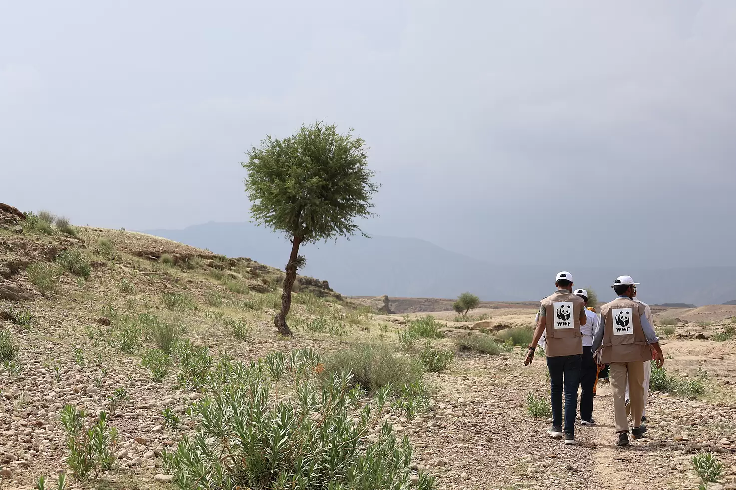
Standing amid vast, arid expanses, often without a single tree in sight, I was struck by how resilient beauty can be. At first glance, one might see emptiness: stones, dry gullies, and cracked soil stretching endlessly across the horizon. Yet, in those stark stretches of Balochistan and Sindh, there was a quiet strength. Subtle contours marked where water once flowed, and traces of old channels hinted at life that had once thrived. These regions were not always this dry. They once held richer soils, stronger springs, and communities more secure in their livelihoods - before recurring floods, droughts, and a changing climate began to erode that balance.
We travelled to the field sites in Sindh and Balochistan, embarking on hours of off-roading beneath a flickering heat haze, with only scattered vegetation along the way, until small communities slowly emerged, tucked between ridges and dry riverbeds that can become raging torrents overnight. These are regions that many Pakistanis will never see. Not because they don’t exist, but because they are far removed from our urban corridors of opportunity. Yet it is these very landscapes, and the people who call them home, that sit on the frontline of climate change disasters. The communities we met live in some of the most exposed environments, navigating water scarcity, livelihood uncertainty, and climate extremes with extraordinary resilience. And yet, it raises an important question: should resilience be their only option?
Drought and flood are not opposites. They are seasons of the same struggle.
Standing on cracked riverbeds and dry canals, the urgency was unmistakable: we cannot keep rebuilding what we could have prevented breaking.
Takeaways from the Field
This visit allowed us to validate design decisions, deepen our understanding of local dynamics, and refine strategies based on real terrain and community context. The project's provincial offices hire local staff who are closely connected to the intervention sites, but this visit enabled the central strategy team to see the challenges and opportunities firsthand. This on-the-ground insight ensures that our interventions are not only technically sound, but practical, equitable, and built for long-term impact.
Fieldwork like this is essential because resilience cannot be designed from conference rooms. In every location, the land told a story of interdependence. Seasonal rivers vanish for months and then return with destructive force. Communities rebuild the same breached embankments year after year. Traditional knowledge is still alive, but under pressure. The visit allowed us to identify challenges proactively and recognise that many of our potential bottlenecks lie in logistics, such as transporting materials, reaching remote valleys, and accessing resources. Others are social in nature: land access, community buy-in, and variability in seasonal flow dynamics. These complexities cannot be fully understood through reports or models alone; they must be seen, walked through, and discussed directly on the ground.
Interventions: where prevention becomes practice
The team visited multiple intervention sites, each of which revealed a different layer of risk, and a different opportunity to reimagine how disasters can be prevented rather than endured. In the flood-prone plains of Sindh, the planned dispersal embankments at Gaji Shah will guide floodwaters across designated corridors, slowing the flow to reduce downstream peaks and protect nearby settlements. Further along the landscape in Tando Rahim Khan, retention areas will capture seasonal floodwater, allowing it to percolate into the soil and recharge aquifers, simultaneously reducing immediate hazard and building long-term water security. Moving into the rugged terrain of Balochistan, the gabion bunds and vegetative buffers at New Shambani are designed to stabilize eroding riverbanks and safeguard agricultural land and community infrastructure, using hybrid solutions that pair engineering with ecosystem restoration.
These interventions are more than physical structures; they reflect a fundamental shift - from resisting natural systems to working with them.
Integrated, Multidisciplinary Approach
Building resilience, therefore, requires integrated thinking, where hydrology, ecology, engineering, and social inclusion work together. Only through cross-disciplinary collaboration can we deliver long-term, sustainable outcomes that are responsive to both the landscape and the people who depend on it. For too long, disaster management in Pakistan has been reactive, arriving only after the loss. But true resilience demands prevention, anticipation, and systems of thinking. It means rejecting siloed approaches and narrow technical lenses, because disasters are not isolated events; they are the outcomes of how we manage land, water, infrastructure, governance, and community agency as interconnected layers of a single system. If one fails, all fail. If one strengthens, all strengthens.
The Power of Local Ownership
One of the strongest lessons from this mission was the power of local ownership. Engaging with field teams and community representatives made it clear that our decision to recruit locally was not just a logistical convenience; it was, and remains, a strategic imperative. Local staff are not outsiders navigating unfamiliar terrain; they are part of these ecosystems who know which lands flood first, where the water tables have receded, and which communities are most vulnerable. Equally important is their motivation. Many are not just implementing interventions - they are helping restore the very lands that sustain their families. That sense of belonging transforms project work into purpose. It builds continuity, trust, and accountability to affected populations. When communities see their own members leading the effort, ownership deepens, and resilience becomes a shared goal rather than an external plan.
Insights on Resilience and Stewardship
The farther we travelled, the more we realized that this story of resilience is not just about climate adaptation. It is about dignity, and rekindling capacity - not simply imposing it. Our mission is to help restore balance to landscapes that still remember abundance, and to communities that still hold hope. This privilege of seeing, listening, and learning must ground us so that we never forget we are stewards, not saviours, and that the real work of disaster reduction lies far beyond our offices, in remote corners where communities may never read project reports or attend climate conferences.
As we move forward, the memory of those landscapes and faces serves as both a reminder and a responsibility: climate resilience begins with humility, collaboration, and the will to bridge divides between people and nature, between policy and practice, and between what we envision and what we deliver.
Written by Amal Durrani, Manager Communications & Advocacy, Recharge Pakistan, WWF-Pakistan

The partnership between WWF and IKEA on responsible cotton has been a pioneering initiative with the focus on driving transformation in the global cotton industry. This collaboration has focused on reducing the environmental and social impacts of conventional cotton farming, ultimately leading to the establishment of the Better Cotton Initiative (BCI) and the adoption of sustainable cotton practices at scale. Over the years, the partnership has expanded its impact, promoting water stewardship, biodiversity conservation, and regenerative agriculture.
The Beginning (2002–2005): Addressing a Global Challenge
In the early 2000s, conventional cotton farming was associated with severe environmental degradation, excessive water consumption, pesticide use, and poor labor conditions. Recognizing the need for a sustainable alternative, WWF and IKEA initiated pilot projects in India and Pakistan in 2002. These projects aimed to introduce environmentally friendly farming techniques that would reduce water and chemical use while improving farmer livelihoods. The pilot projects demonstrated promising results, showcasing how farmers could adopt better agricultural practices without compromising yields or profitability. This laid the foundation for the next phase of the partnership.
2005: The Birth of the Better Cotton Initiative (BCI)
In 2005, the cotton programme was officially established within the partnership. In the same year, WWF and IKEA, along with other stakeholders, established the Better Cotton Initiative (BCI) now known as Better Cotton to promote responsible cotton production on a global scale. BCI set standards for reducing pesticide and water use while improving social and economic conditions for farmers.
2005–2015: Scaling Up Sustainable Cotton
During this period, BCI gained momentum, and IKEA integrated responsible cotton sourcing into its global supply chain and by 2013, over 300,000 farmers were trained in responsible cotton production under BCI. IKEA also set a target to source 100% of its cotton from more sustainable sources by 2015, a goal it successfully achieved. This commitment influenced other brands to follow suit, which contributed to the broader industry’s adoption of BCI standards.
2015–2020: Expanding the Impact
By 2015, IKEA was sourcing all its cotton from more sustainable sources; BCI-certified, organic, recycled and others, making it one of the first global brands to achieve this milestone. During this period, the WWF and IKEA partnership expanded its scope to include and protect ecosystems in cotton-growing regions of Pakistan and focused on expanding its reach and deepening its impact through thematic projects on water conservation and water use efficiency, climate smart agriculture, agroforestry and cotton value chain development. These projects also had strong components on improving livelihood of rural women through imparting skills for alternate source of income.
2020–Present: Climate Smart /Regenerative Agriculture
WWF and IKEA partnership has made significant strides in promoting Climate Smart Agriculture to help improve the lives of rural cotton producing communities in Pakistan. Through dedicated efforts, over 100,000 farming families have been equipped with knowledge and skills to embrace climate-smart agricultural practices. Furthermore, partnership’s commitment to gender equality and empowerment has resulted in providing training opportunities to 10,000 women workers, ensuring their active participation in the agricultural sector. Additionally, a milestone was achieved for environmental restoration and conservation through planting ‘one million trees’ in cotton landscapes, enhancing biodiversity and contributing to the overall well-being of the ecosystems.
2020 is also when the partnership introduced, surface mount devices, mobile training units equipped with digital resources such as videos demonstrating the use of advanced farm machinery tools, real time data from localized weather stations, and interactive tutorials on water conservation, bringing on-hands learning to farmers on -site. Through the adoption of these practices during the cotton cropping seasons between 2020 and 2024, farmers achieved a remarkable 23% reduction in greenhouse gas emissions*, significantly contributing to a lower carbon footprint in cotton farming. From a total of 80,000 farmers, over 20,000 farming families have been trained through these trainings conducted through mobile training units and the remaining are trained through regular training sessions conducted by the field staff.
As the global sustainability landscape evolved, WWF and IKEA began focusing on regenerative agriculture, to actively restore soil health, improve biodiversity, and reduce carbon footprints. The key elements of this new approach include:
-
Reducing environmental impact further: Moving towards organic and regenerative farming methods that enrich the soil.
-
Enhancing supply chain transparency: Ensuring ethical sourcing and traceability in cotton production.
-
Climate action: Addressing the climate impact of cotton farming by promoting low-carbon agricultural techniques.
Key Achievements of the WWF and IKEA Partnership over the past two decades:
-
Co-founding and expanding the Better Cotton Initiative (BCI) - now the world’s largest sustainability initiative for cotton.
-
Helping train over 400,000 farmers in responsible cotton farming across India and Pakistan
-
Planting ‘two million trees’ in cotton landscapes of Pakistan and India between 2020- 2025, enhancing biodiversity and contributing to the overall well-being of the ecosystems.
-
Achieving 100% more sustainable cotton sourcing for IKEA since 2015.
-
Reducing water and pesticide use, benefiting both the environment and farmers’ health.
-
Promoting biodiversity and nature-positive farming as part of the shift towards regenerative agriculture.
-
Between 2020 and 2024, farmers achieved a remarkable 23% reduction in greenhouse gas emissions*, significantly contributing to a lower carbon footprint in cotton farming .
The WWF and IKEA partnership on responsible cotton is a model for how corporations and environmental organizations can collaborate for global impact. What started as a small pilot project in 2002 has evolved into a transformative force in the textile industry, proving that sustainability and business success can go hand in hand. As the partnership moves forward, its focus on regenerative agriculture and climate resilience will set new benchmarks for sustainable cotton production worldwide.
Footnote: * GHG reduction emissions calculated via Cool Farm Tool (CFT) inputting farm-specific data for crops and livestock
Written by: Asad Imran, Director Food and Agriculture, WWF-Pakistan.
When we think about the leather industry, we often picture tanneries, craftsmanship, and international exports. But behind this visible supply chain lies a hidden skilled workforce. It has been observed that women, persons with disabilities, ethnic minorities, and others from disadvantaged backgrounds are often not included in this workforce. Their exclusion isn’t just a missed opportunity; it is a systemic issue that calls for deeper change. That’s where Gender Equality and Social Inclusion (GESI) comes in.
GESI is more than a development sector acronym and a compliance requirement by brands. It is a transformative framework that advocates for the full and fair inclusion of people, regardless of gender, disability, ethnicity, or socioeconomic status, in all aspects of society and the economy.It challenges entrenched norms, discriminatory hiring practices, and systemic barriers that continue to limit opportunities for underrepresented groups.
GESI isn’t about token training sessions or isolated diversity programs. It is about reshaping systems to make space for everyone.
Gender gaps and unequal representation in the leather sector
In many leather-producing countries, including Pakistan, the sector remains heavily male-dominated, particularly in technical, supervisory, and decision-making roles. According to the International Labour Organization (ILO), women make up less than one percent of the formal workforce in Pakistan’s tanneries. When women are present, they are often confined to low-skilled, informal jobs with little job security or growth opportunities.
Why does this happen?
-
Traditional gender roles suggest that leather work is physically demanding or unsafe.
-
Workplace environments often lack facilities or policies that support women’s participation.
-
Cultural and social norms discourage women’s entry into industrial work.
While gender disparities are significant, GESI doesn’t stop at gender.
Persons with disabilities, ethnic minorities, and individuals from disadvantaged communities also face exclusion. These range from a lack of accessible workplaces to the absence of inclusive hiring and workplace safety policies. According to World Bank statistics, only 19.92% of persons with disabilities in Pakistan are employed. Many are simply left out of the conversation entirely.
Why does inclusion make business sense?
This is not just a social or moral issue, it is an economic one.
-
Companies in the top quartile for gender diversity are 25% more likely to outperform financially, according to McKinsey (2020).
-
Diverse teams bring new perspectives, foster innovation, and improve employee satisfaction and retention.
-
Ethical buyers and global markets increasingly demand transparency and equity in supply chains.
GESI is no longer a ‘nice-to-have’ but a business imperative for companies aiming for long-term sustainability, credibility and growth.
The conversation around leather and sustainability often focuses on pollution, but it must include social impacts too. Communities near tannery clusters, particularly women and children, suffer the most from untreated effluents, drinking water contamination and health risks. Yet, the same communities often have the least say in how tanneries are regulated or upgraded. GESI frameworks ensure that those most impacted by environmental degradation are not only heard but empowered to co-design solutions that directly impact their health and future.
What can be done: Practical steps towards inclusion
Integrating GESI into the leather industry requires a deliberate shift in both mindset and practice. It starts with collecting accurate, disaggregated data to understand who is being excluded and why. From there, businesses and institutions can design inclusive interventions, such as gender-sensitive recruitment policies, targeted technical training programs, safe working environments, and flexible work arrangements. Support for mentorship and leadership development is also key to advancing women and marginalized individuals into decision-making roles where they can influence change from within. This must be the part of core business strategy, not an afterthought or compliance exercise.
The leather industry is at a crossroads. As global supply chains evolve to prioritize ethics, transparency, and environmental sustainability, inclusion must not be left behind. Now is the timely opportunity to embed GESI principles from the ground up. This is our chance to move beyond efficiency and productivity alone, and towards equity, resilience and justice. Because industry and manufacturing is not just about products, it is about people.
Written by Maryam Eqan, Senior Officer, Freshwater Programme, WWF-Pakistan
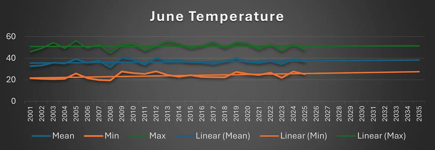
Satellite readings reveal the alarming levels of temperature Lahore has reached. For temperature, satellite-derived surface readings help identify emerging challenges and highlight trends.The annual temperature presents not only a steady upward hike in maximum but minimum temperatures as well.
From 2001 to 2025, the city’s climate has undergone a dramatic shift. Back in the early 2000s, summer temperatures usually topped out at around 42–43°C, but that was just the beginning. The first decade (2001-2010) established a baseline where temperatures followed predictable seasonal patterns, occasionally breaching 45°C during exceptional heatwaves. While the first fifteen years showed a relatively steady increase of about 0.2°C per year, the last decade has seen that rate jump to nearly 0.3°C annually.
Today, the urban heat island effect has become more pronounced, with densely built-up areas now regularly showing 8-10°C warmer temperatures than surrounding rural zones during summer afternoons. What used to be a 2–3 month period of dangerous temperatures now stretches to 5-6 months in recent years.
This proves that the season of extreme heat has expanded dramatically.
Worsening June Heat
The month of June has altered the climatic structure of Lahore. Previously, where the maximum temperature reached 44-45°C in the early 2000s, recent years have consistently recorded peaks above 48°C, with the unprecedented 50.1°C reading in June 2022. This dangerous new threshold is concerning as minimum nighttime temperatures have kept pace, rising from 28-29°C to 34-35°C, over the same period.
However, the data in the month of June reveals a more troubling trend that demands our immediate attention. Earlier, Lahore experienced 3-4 day periods of temperature reaching 45°C in June.Today, the city experiences over 12 such days annually. This increasing frequency is what climate scientists call "compound heat events". This includes consecutive days of temperatures not only peaking extremely high during the day but failing to drop below 30°C at night.
Public Health Fallout
What implication do these temperature trends have on urban life? Public health systems face growing burdens from heat-related illnesses particularly among outdoor workers, elderly populations, and low-income communities lacking access to cooling. Infrastructure designed for historical climate norms is failing - roads softening, power grids overloading, and buildings becoming heat traps.
The city's green spaces and water resources are under unprecedented stress, with evaporation rates increasing and vegetation struggling to survive.
The need to highlight this change is the severe health consequences of this phenomenon as humans require adequate night time cooling to recover from daytime heat exposure. Hospital records show emergency visits for heat-related illnesses now correlate more strongly with high minimum temperatures than with daytime peaks.
The data leaves no question that Lahore has entered a new climate territory that demands urgent adaptation. Traditional coping mechanisms such as siesta schedules, building designs, urban planning approaches, were developed for a climate that no longer exists. The projections are clear: Lahore is no longer experiencing a temporary heat anomaly but a permanent shift in its climate, one that must urgently redefine how we design, plan, and protect our cities and communities.
Written by Usama Maqsood, GIS Specialist, WWF-Pakistan

Marine turtles are among the ocean’s most wide-ranging and ecologically important species. Yet despite their status, they are often overlooked in broader marine conservation and policy frameworks. During their life cycle, they span vast distances — from coastal nesting beaches to offshore foraging grounds — and encounter a range of threats along the way. Addressing these threats requires more than isolated efforts; it demands connected, collaborative strategies grounded in ecological reality.
In Pakistan, we’ve seen these dynamics firsthand. A green turtle nesting along the Balochistan coast may forage deep into the Arabian Sea. A juvenile hawksbill, found stranded or reported as a carcass in Jiwani, could belong to a population shared with Iran or Oman. Similarly, post-nesting green turtles may migrate toward the Indus Canyon or forage between Churna and Astola Islands. The increasing number of olive ridley carcasses reported along the Balochistan coastline suggests these turtles may be washing ashore while migrating from offshore waters to nearshore foraging areas.
These examples highlight why marine turtle conservation cannot be restricted by geopolitical boundaries. The threats they face — from fisheries bycatch and habitat loss to marine debris and changing ocean conditions — operate across jurisdictions. Effective conservation must therefore be regionally informed and transboundary in scope.
Multilateral platforms like the CMS–IOSEA Marine Turtle MoU and the Northern Indian Ocean Marine Turtle Task Force (NIO-MTTF) offer structured ways to address these shared challenges. They promote coordinated action, knowledge exchange, and policy alignment among countries with overlapping turtle populations. These efforts are further supported by emerging tools, such as Regional Management Units (RMUs), which help clarify the spatial and ecological connections between nesting, migratory, and foraging habitats. While RMUs are not a standalone solution, they contribute valuable context for planning and prioritizing conservation at scale.
Progress in Pakistan — and the Path Forward
Pakistan has made meaningful progress in marine turtle conservation over the years. This includes the protection of key nesting beaches, the declaration of Churna Island and Astola Island as Marine Protected Areas (MPAs), the establishment of community-led patrols, and the incorporation of marine turtles into national and provincial biodiversity strategies. WWF-Pakistan has played an active role in supporting these initiatives — from nest monitoring and stranding response to fisheries engagement and public outreach.
However, a lot remains to be done. Offshore and migratory habitats — particularly those critical to juvenile development and adult foraging — are still under-monitored and under-protected. Without integrating these areas into national marine planning and fisheries policy, much of the conservation work risks being incomplete.
Coordinated Action for Lasting Impact
Moving ahead, we must focus on strengthening regional collaboration and scaling up data-driven action. This includes improved coordination with national and neighbouring countries, expanded monitoring of turtle movements and mortality, and increased support for locally led solutions such as safe-release protocols and bycatch reduction practices.
Marine turtles are not only a shared natural heritage but also indicators of the broader health of our marine ecosystems. Their conservation requires more than technical measures — it calls for long-term partnerships, political will, and a shared commitment to protecting the spaces they depend on.
Filling the Gaps: Linking Land and Sea
While progress has been made, the integration of offshore and migratory habitats into national marine spatial planning remains limited. Post-nesting migrations, juvenile foraging zones, and bycatch hotspots are still poorly understood and often fall outside protected areas. To address this, we need better data, stronger monitoring, and a more connected approach that links nesting site conservation with the wider seascape marine turtles rely on throughout their lives.
Looking ahead, tools such as Important Marine Turtle Areas (IMTAs) — combined with regional collaboration — can help identify and protect these critical habitats. In Pakistan and across the Northern Indian Ocean, aligning our conservation strategies with the full ecological range of turtles will be key to building ecosystem-based, long-term solutions. This also supports broader commitments under frameworks such as CMS–IOSEA, CITES, and the SDGs.
Ultimately, marine turtles are a shared resource — and a shared responsibility. Protecting them effectively means thinking beyond borders, beyond nesting sites, and committing to coordinated action across the entire range of their life cycle.
WWF-Pakistan continues to work with CMS–IOSEA partners, NIO-MTTF members, national like-minded NGOs and coastal communities to safeguard marine turtles and the marine environments they rely on — from nesting beaches to deep-sea migratory corridors.
About the Author
Shoaib Abdul Razzaque is the Focal Point for WWF’s Ocean Practices and serves as Coordinator of the Marine Programme at WWF-Pakistan. He is also the Vice Chair and NGO Focal Point for Pakistan to the CMS–IOSEA Northern Indian Ocean Marine Turtle Task Force (NIO-MTTF).

Every year, across continents and climates, billions of migratory birds take flight, guided by instinct, shaped by millennia, and sustained by ecosystems that offer them food, rest, and refuge. Their journeys stretch across hemispheres and histories – ancient, tireless messengers of balance and continuity. For generations, Pakistan has been one of those resting places, though today, fewer birds arrive, and fewer stay.
The country sits along a major migratory route used by birds journeying between Siberia and South Asia, referred to as the Indus Flyway. As part of the broader Central Asia Flyway, it serves as a critical corridor for millions of waterbirds, including threatened and globally significant species. According to a 2023 report by BirdLife International, the Indus Basin provides essential stopover, breeding, and wintering habitats that support the survival of over 230 migratory bird species along this route. A preliminary working list of internationally important sites compiled from the Important Bird and Biodiversity Areas (IBA) database identifies 1,717 such sites across the flyway, including 79 potential new sites in six countries, including Pakistan. The report mentions that Pakistan currently holds 40 confirmed IBAs, with one additional site proposed, bringing its national total to 41.
Wetlands like Manchar Lake, Chashma Barrage, and the Indus Delta once teemed with northern pintails, flamingos, cranes, and ruddy shelducks. Their arrival marked the rhythm of seasons, and their presence was a sign of ecological balance. Today, these sites are part of a larger network of habitats recognized for their international importance under the Central Asian Flyway. Pakistan’s role is not only ecological but also strategic, with the country identified among those with the most comprehensive climate and biodiversity policy frameworks in the region.
But in recent decades, the skies have grown quieter.
Wetlands have been drained or polluted, and floodplains have been severed. Rising temperatures, shifting rainfall patterns, and human encroachment have transformed the very landscapes birds depend on. These changes are not unique to Pakistan. According to WWF’s Living Planet Report 2022, populations of migratory freshwater birds have declined by a staggering 81% globally since 1970, making them one of the fastest-declining groups of species on Earth. The 2023 BirdLife International report further reinforces this trend, identifying habitat loss and degradation, unsustainable land use, riverbed sand mining, pollution, and altered water availability as major threats across the Central Asia Flyway; many of which are directly linked to the landscapes and systems that Recharge Pakistan aims to restore.
In Pakistan, this decline is painfully visible. Bird counts by the Sindh Wildlife Department show that Manchar Lake, once a thriving sanctuary for wintering birds, has seen migratory populations drop by more than half over the past two decades. The Indus Delta’s fragile mangrove ecosystems, which offer critical feeding and roosting sites, are also shrinking due to upstream water diversion and coastal development. In places where skies once pulsed with wingbeats, silence now echoes. Fewer birds are arriving, and those that do arrive often stay for shorter periods, unable to find the conditions they once relied on.
The loss of migratory birds is not only a sign of ecological imbalance, but also a cultural and environmental rupture.
Communities that once marked the seasons by the arrival of cranes and flowing water now face climate uncertainty. When birds disappear, it signals the breakdown of a system that nourishes people, land, and life.
But hope remains – in the wetlands we can still restore, and in the habitats we can still protect.
As one of Pakistan’s largest nature-based solutions projects, Recharge Pakistan is applying Ecosystem-based Adaptation (EbA) to manage floods and restore degraded landscapes. EbA goes beyond the use of traditional grey infrastructure and harnesses the power of nature to protect and restore natural systems, wetlands, forests, and floodplains, so they can continue to provide water storage, erosion control, and biodiversity support. The approach also supports communities in building long-term resilience against climate shocks such as floods, droughts, and water scarcity by integrating indigenous knowledge and local practices into disaster-curtailing mechanisms.
Pakistan has already seen the power of EbA in action, particularly through large-scale mangrove restoration in the Indus Delta. These efforts have improved coastal resilience by reducing shoreline erosion, buffering inland communities from surges, and enhancing local fisheries, all while restoring habitat for migratory birds and marine life. Documented by the Nature-based Solutions Initiative at the University of Oxford, this community-led initiative has also strengthened local livelihoods by supporting sustainable seafood harvesting and providing natural protection against climate risks.
Globally, one of the most recognized EbA success stories is the restoration of the Urdaibai estuary in the Basque Country of Spain, a UNESCO Biosphere Reserve and a crucial stopover on the East Atlantic Flyway. This wetland, encompassing diverse habitats such as marshes, forests, and beaches, serves as a vital resting and feeding ground for numerous migratory bird species, including ospreys, spoonbills, and various waders. The establishment of the Urdaibai Bird Center in 2012 has been instrumental in monitoring avian populations and promoting conservation efforts. Through habitat restoration and scientific research, the center has documented a significant increase in both the diversity and number of migratory birds utilizing the estuary, underscoring the direct benefits of ecosystem-based adaptation measures on avian biodiversity.
Across Dera Ismail Khan, Ramak Watershed, Manchar Lake, and Chakar Lehri, Recharge Pakistan is building on these lessons. It is reviving floodplains, recharging aquifers, and restoring wetland habitats that serve both people and wildlife. The WWF-Pakistan 2023 Annual Report outlines how allowing floodwaters to spread over natural depressions can create seasonal wetlands that support both birds and agriculture. At Manchar Lake, the project focuses on improving water quality and ecological conditions to bring back native fish, aquatic plants, and bird populations, further highlighting the project’s aim to integrate biodiversity into climate adaptation strategies.
Healthy wetlands do not just absorb floods, they support insect life, aquatic vegetation, and all the food sources migratory birds rely on. They regulate microclimates, purify water, and protect communities from the worst effects of droughts and disasters.
Every recharge intervention, every restored channel, every re-greened plain is a quiet invitation: you can come back now.
These are not just environmental interventions; they are acts of foresight and equity. They offer women safer water access, farmers more fertile land, and youth a future rooted in sustainability rather than survival. They reconnect people with the ecosystems they live within – not above – and create co-benefits that ripple through generations.
Written by Annarita Cordella, Communications Intern, Recharge Pakistan, WWF-Pakistan.

In today’s interconnected world, consumers and stakeholders demand transparency in the products they use. For the leather industry, this is no different, and transparency begins with traceability; the ability to track the leather’s journey from raw material to finished product.
As one of the oldest industries in the world, the leather sector embodies a rich history of craftsmanship, innovation and economic significance. Using byproducts from the meat industry as raw materials, the sector is renowned for producing durable and versatile products and continues to support livelihoods and drive commerce globally. However, alongside these contributions, leather production carries significant environmental implications, such as the use of toxic chemicals, greenhouse gas emissions, unmanaged solid waste, and unethical rearing of animals. Addressing these challenges requires identifying risks by embedding traceability at every stage of the value chain. The leather value chain is a fascinating yet intricate web that connects livestock farms to fashion runways. However, hidden within this journey are significant challenges that impact the environment. Without clear visibility into these stages, addressing these issues remains an uphill battle and that’s where traceability becomes a game-changer.
By mapping the leather journey from farm to factory, traceability equips businesses with the insights needed to tackle environmental challenges head-on. It’s more than just tracking, it’s the industry’s roadmap to accountability and improvement. Shedding light on every step of the value chain — from sourcing raw hides and skins, tanning and finishing and manufacturing of products — ensures transparency and highlights key risks associated with every step in the value chain. It builds trust and accountability, ensuring products meet the highest ethical and environmental standards. Imagine knowing exactly where your leather product comes from, whether it was ethically sourced, how it was manufactured, etc.; that is the power of transparency.
With traceability, businesses can also access global markets by ensuring compliance with upcoming international regulations, such as the European Union (EU) Deforestation Regulation (EUDR), the Corporate Sustainability Reporting Directive (CSRD), and the Corporate Sustainability Due Diligence Directive (CSDDD), as well as existing standards like the Leather Working Group standards and the Sustainable Leather Foundation (SLF) standards. For brands and consumers, this ensures confidence in choosing products that align with their values.
WWF-Pakistan’s project, “Pakistan Leather Sector: Traceability, Cleaner Production, and Circularity” funded by the UK International Development, through the SMEP Programme exemplifies how traceability can address the industry’s challenges. By introducing a digital traceability toolkit and promoting circular and cleaner production practices, the project aims to set a stage for tanneries to reduce pollution, recycle waste and ensure compliance with sustainability standards.
Disclaimer: The UK Government funds this pilot activity “Pakistan Leather Sector: Traceability, Cleaner Production, and Circularity” through UK International Development; however, the views expressed do not necessarily reflect the UK Government's official policies.
By Adeel Younas, Project Manager SMEP, WWF-Pakistan and Maryam Eqan, Senior Officer, WWF-Pakistan

Sustainable fishing is crucial for safeguarding marine ecosystems and ensuring that the livelihoods that depend on these ecosystems remain intact. However, challenges such as overfishing, fishing down the food chain, bycatch entanglement, habitat destruction and economic vulnerabilities persist; particularly for coastal communities in Pakistan. Addressing these issues requires comprehensive actions, including training and facilitation to adopt better practices, regulatory enforcement and diversification of income sources. However, the journey towards sustainability is riddled with obstacles, such as financial constraints and resistance to change stemming from local customs and norms. To tackle some of these challenges, WWF-Pakistan and Engro Foundation collaborated on initiatives in Ibrahim Hyderi and Rehri Goth. For generations, fishermen in these communities have relied on the ocean for their livelihoods, but their dependence on unsustainable practices has led to environmental degradation and economic challenges. Limited resources and lack of market access have made it difficult for them to explore alternative livelihoods or adopt modern techniques. Cultural tradition and inadequate infrastructure further compounded the problem, creating resistance to change. Recognising these barriers, WWF-Pakistan and Engro Foundation implemented a myriad of interventions designed to tackle these challenges head-on.
One of the first steps was addressing the economic vulnerabilities of fishermen. Practical training sessions on sustainable fishing practices equipped them with improved fish preservation techniques and ice-boxes were distributed to reduce post-harvest losses. These efforts immediately demonstrated tangible benefits: fish waste was minimised and incomes increased by 30 per cent. This success highlighted the potential for environmental sustainability and economic growth to coexist, inspiring wider adoption of these practices with the fisher community.
Training sessions also focused on sustainable fishing techniques, such as longline fishing, which significantly reduces bycatch. Fishermen were further trained in the safe release of entangled bycatch to help maintain the marine ecosystem’s delicate balance. By involving local communities in planning, training and execution, the initiative fostered a sense of ownership and accountability, ensuring the longevity of these practices. Moreover, this initiative also recognised the vital role of women in driving change. Women were provided with training in skills, like sewing and handicrafts, enabling them to contribute to household incomes substantially. This not only contributed to gender equality but also helped strengthen financial stability for families transitioning to sustainable practices. Alternative livelihoods, such as aquaculture and crab fattening, offered additional significant economic rewards. For instance, crabs, which once sold for PKR 100 each, now fetched PKR 600, providing the economic potential of these initiatives.
Youth engagement has also emerged as another crucial component of the initiative. By educating over 2,500 students through various recreational activities and nature clubs, the initiative fostered awareness and responsibility among young people, empowering them to become future stewards of the environment.
While challenges persist, particularly around finances and market access, the success stories from these initiatives offer a beacon of hope. WWF-Pakistan and Engro Foundation’s collaborative efforts have demonstrated that with the right combination of training, resources, and community empowerment, it is possible to uplift entire communities while protecting the environment. The journey toward sustainability may be long, but the lessons learned and successes achieved so far affirm that a sustainable future is always within reach when communities come together or collaborate for the greater good.

The Aral Sea, once the fourth largest lake in the world, is now a tragic memory replaced by the vast Aralkum Desert. Stretching across 62,000 square kilometers, this ecological disaster unfolded as the Soviet Union diverted the lake's primary water sources, the Amu Darya and Syr Darya rivers, to fuel agricultural expansion. The story of the Aral Sea’s demise is a stark warning for water-stressed nations like Pakistan, where unsustainable practices could lead to similar environmental catastrophes.
The Collapse of the Aral Sea
In its prime, the Aral Sea’s ecosystem thrived, fed by rivers flowing through Central Asia’s diverse landscapes. However, in the mid-20th century, the Soviet Union began redirecting massive amounts of water to grow cotton and other crops in Uzbekistan. Between 1913 and 1960, water withdrawals from the rivers skyrocketed to 64 billion cubic metres annually, leaving only 56 billion cubic metres to replenish the Aral Sea. By 1985, this figure had dropped to just 2-5 billion cubic metres, far less than the 40 billion cubic metres lost to evaporation each year.
As the water receded, the lakebed transformed into the Aralkum Desert, a barren wasteland of salt and toxic dust. This environmental catastrophe not only devastated local communities but also altered regional weather patterns and created a public health crisis. The Aral Sea’s fate is a grim reminder of the consequences of overexploiting natural resources.
The Warning for Pakistan
Pakistan is already among the most water-stressed countries in the world. According to the Food and Agriculture Organization (FAO), the country withdraws 74.4% of its total renewable freshwater annually, with 85% of this allocated to agriculture. In 2008 alone, Pakistan’s agriculture sector consumed 172.4 billion cubic metres (BCM) of water, up from 150.3 BCM in 1975. With a rapidly growing population projected to reach 403 million by 2050—the demand for food and water will only increase.
Adding to the challenge, the Intergovernmental Panel on Climate Change (IPCC) warns that Himalayan glaciers, a critical source of water for Pakistan’s rivers, are melting faster than anywhere else on Earth. This means Pakistan faces an initial surge in water flow, followed by severe shortages as glaciers shrink. The parallels to the Aral Sea’s story are alarming.
Inefficiencies in Water Use
Pakistan’s water management system is riddled with inefficiencies. FAO estimates that 25-30% of water in canals and watercourses is lost to leakage, while another 25-40% is lost during application in agricultural fields. Altogether, about 60% of water is wasted due to infrastructure issues and poor practices. By improving canal maintenance and promoting efficient irrigation techniques, Pakistan could save up to 15 BCM of water annually.
Seawater intrusion in the Indus Delta is another pressing issue. According to IUCN, one-third of Thatta’s agricultural land amounting to 0.5 million hectares—has been rendered unusable due to saltwater encroachment. These challenges underscore the urgent need for sustainable water use.
Productivity Challenges in Agriculture
Pakistan’s agricultural productivity also lags behind regional and global benchmarks. The country produces 2.72 tons of crops per hectare, compared to India’s 2.96 tons, Bangladesh’s 4.36 tons, China’s 5.89 tons, and Japan’s 6.10 tons. Japan produces more than twice the food per hectare as Pakistan. This stark disparity highlights the potential for Pakistan to increase its yield through better resource management and modern farming techniques.
Learning from the Aral Sea
The story of the Aral Sea offers valuable lessons for Pakistan:
-
Promote Water Efficiency: Pakistan must prioritize water conservation by adopting drip irrigation and training farmers to use water more efficiently. Modern irrigation techniques can significantly reduce water waste while boosting crop yields.
-
Invest in Infrastructure: Regular maintenance of canals and watercourses can prevent leakage and save billions of cubic metres of water annually.
-
Adapt to Climate Change: With glaciers melting rapidly, Pakistan needs a robust strategy to manage fluctuating water supplies. Building reservoirs and implementing water-saving technologies can help mitigate future shortages.
-
Enhance Agricultural Productivity: By adopting high-yield crop varieties and sustainable farming practices, Pakistan can produce more food with fewer resources, reducing the strain on water and land.
-
Protect the Indus Delta: Addressing seawater intrusion and rehabilitating affected lands is crucial to preserving agricultural productivity in coastal regions.
Pakistan cannot afford to repeat the mistakes that led to the Aral Sea’s destruction. As a water-stressed nation, every drop counts. Resource efficiency is not just an option; it is a necessity for survival. By taking proactive steps to conserve water, modernize agriculture, and adapt to climate change, Pakistan can ensure a sustainable future for its people and ecosystems.
The Aral Sea’s story is a cautionary tale of what happens when we exploit nature without regard for long-term consequences. Pakistan has the opportunity to learn from this tragedy and take decisive action to protect its natural resources.
Written by Ayoub Hameedi, a Stockholm-based policy analyst and the founder/Operations Manager of Project Green Earth (www.projectge.org).

As we stand on the brink of transformative urban growth, the question of who will shape and own the future of our cities becomes increasingly important. Urban spaces are more than just buildings and roads; they are living ecosystems where people, cultures, and economies intersect. But as cities expand, who are the custodians of these evolving landscapes? Who holds the right to access, shape, and benefit from the opportunities of future cities? The answer lies in one key principle: inclusion.
Traditionally, urban planning and development have been dictated by the economic and political elites, often overlooking marginalised communities—those most vulnerable to the impacts of poorly planned urbanisation. However, the concept of "rights holders" in urban spaces goes beyond the wealthy and powerful. Every city resident—regardless of socioeconomic status, gender, ability, or ethnicity—should have the right to shape the city they inhabit.
The future city should belong to the people who contribute to its growth and liveliness. This includes not only those who live and work in the city today but also future generations who will inherit the environmental and social impacts of current development choices. Moreover, the rights holders of future cities are not just individuals; they include communities, small businesses, and even ecosystems that play crucial roles in sustaining urban life.
As cities face increasing pressures from climate change, it becomes essential to recognise that those most affected by these changes often have the least voice in city planning. Rising sea levels, heatwaves, and pollution disproportionately impact lower-income residents, people with disabilities, and other vulnerable groups. If future cities are to be sustainable and resilient, their planning must prioritise inclusive climate action. This means embedding social equity into climate policies and ensuring that marginalised groups are not left out of discussions about urban resilience.
Building on this foundation of inclusive urbanism, it is clear that the future of cities will depend on our ability to ensure that all voices are heard. This will require systemic shifts in governance, policymaking, and urban design—moving from a top-down model of development to one that actively engages all rights holders. Participatory planning mechanisms, such as community consultations and co-creation processes, must become the norm, allowing local communities, youth, and marginalised groups to have a meaningful role in shaping urban futures.
One way forward is by institutionalising participatory governance frameworks within city administrations. By creating platforms that allow citizens to regularly interact with city planners, governments can better understand the diverse needs of urban populations and make informed decisions that promote equitable access to services, resources, and opportunities. This approach is particularly important as cities adopt climate adaptation strategies, ensuring that vulnerable populations—who are often the hardest hit by climate impacts—are equipped with the tools and resources to survive and thrive in increasingly unpredictable environments.
In addition to governance reforms, innovative urban technologies and data-driven decision-making can help future cities become more responsive to the needs of their residents. Smart city technologies, when implemented ethically and inclusively, can enhance transparency and public participation while offering real-time solutions for challenges like transportation, waste management, and energy consumption. However, this must be done in ways that do not further exclude marginalised groups or deepen inequalities, but rather ensure that technology is a force for inclusion.
The future of cities lies in their ability to be inclusive, equitable, and sustainable. By recognising that every city resident is a rights holder with a stake in urban development, we can build cities that are not just spaces for economic activity but vibrant ecosystems that reflect the diversity, creativity, and resilience of their inhabitants. Through participatory governance, equitable urban policies, and climate-conscious planning, we can ensure that the cities of tomorrow are places where everyone, regardless of their background, has the opportunity to thrive.
Written by Maryam Eqan, Officer Water Sensitive Cities, WWF-Pakistan
Pakistan, a country with a diverse geography ranging from towering mountains to vast plains, relies heavily on freshwater resources. These resources are crucial for sustaining life, supporting agriculture, and driving economic activities. However, the impacts of climate change are increasingly threatening the availability and quality of freshwater in Pakistan.
The Himalayas feed water into the Indus River, making it a major source of freshwater for the country, especially for the Punjabi and Sindhi plains. Up to 65 per cent of Pakistan's agricultural land is irrigated by the Indus River, which accounts for about 90 per cent of the country's food and fibre production. Additionally, freshwater ecosystems such as lakes, wetlands, and rivers are home to diverse species of plants and animals, contributing to Pakistan’s biodiversity and ecological balance.
Freshwater availability and quality
As global temperatures rise, the frequency of extreme weather and fluctuating precipitation patterns are altering the hydrological cycle.
Due to rising temperatures, glacial melting in the Himalayas is increasing. This initially increases river flow but poses a long-term threat as glaciers shrink, reducing the overall water supply. Changes in precipitation patterns are leading to more intense and frequent droughts in some regions while other regions experience increased rainfall and floods as seen in 2022 which submerged almost one-third of the country affecting more than 33 million people. Droughts in certain regions cause greater concerns for water resources. Firstly, surface water becomes scarce, so human needs are not met; secondly, it puts pressure on groundwater resources which are not being replenished naturally. As they are pumped out more frequently leads to a steady decline in the subsurface water quantity. This issue has been reported in parts of Punjab and especially in the Pothohar region where groundwater aquifers are scarcely present.
Increased runoff from rainfall can carry pollutants such as fertilisers, pesticides, and industrial chemicals to more distant areas and into freshwater systems. Furthermore, rising sea level allows saltwater to intrude into freshwater aquifers further depleting sources of quality freshwater. Research by Mehran University of Engineering and Technology, Jamshoro, estimated that about 0.5 million hectares of agricultural land in the Indus Delta had been degraded due to saltwater intrusion, which was about 12 per cent of the total cultivated land (2018).
Pakistan’s freshwater ecosystems are particularly vulnerable to climate change. The life cycles of aquatic species are dependent on temperatures. This has led to a shift in species’ composition and has resulted in biodiversity loss; this has been more relevant in fish species that rely on specific temperatures for spawning. Wetlands, which provide critical habitat for many species are also at risk of drying out or being submerged by rising sea levels.
Agriculture, health and economy
The proliferation of harmful algal blooms and increased pollution due to climate change exacerbate health risks like cholera, dysentery, and typhoid fever. Research on saltwater intrusion also shows that this leads to major health concerns, such as skin diseases, hypertension and cardiac and kidney problems.
Changes in water availability and quality pose significant challenges to agricultural productivity. Droughts can reduce crop yields, while floods can damage crops and infrastructure; increased temperatures and altered precipitation patterns can affect the growing seasons and suitability of certain crops.
Water scarcity and quality issues can also affect the country’s economic growth by affecting industrial processes and energy production. Hydropower generation, which relies on consistent water flow, can be disrupted by changes in river flow patterns, this incurs costs associated with managing water resources.
Way Forward
Efficient management practices are essential to cope with the changing availability of freshwater. This includes implementing climate-smart agriculture and cleaner production technologies in industries, promoting water-efficient practices, and enhancing infrastructure to reduce water loss. Integrated Water Resources Management (IWRM) approaches that consider the entire watershed can help balance competing demands and protect freshwater ecosystems.
Protecting and restoring freshwater ecosystems can enhance their resilience to climate change. Healthier ecosystems are better able to absorb and lessen the impacts of extreme weather events.
Climate change adaptation with decentralised approaches is also a smart move. This is where Nature-based solutions (NbS) play a pivotal role. The interventions, such as greenspaces not only provide a cooling effect but also act as carbon sponges, soaking Green House Gases (GHGs) and stopping them from releasing into the atmosphere. Water Sensitive Urban Design (WSUD) greenspaces also act as a means to collect surface runoff from rainwater and recharge groundwater. Harvesting and conserving freshwater locally reduces flash floods and acts as a means for water storage, ready to be used during droughts.
Transitioning to renewable energy sources, improving energy efficiency, and adopting sustainable land-use practices can reduce emissions and slow the rate of climate change. Additionally, protecting forests and other natural carbon sinks can help suppress carbon emissions and mitigate climate impacts.
Implementation of policies at a national level can also play a key role. The Pakistan National Climate Change Policy (NCCP) discusses many adaptation and mitigation measures to cope with climate change. Capital Development Authority (CDA) has also taken a significant step towards sustainable water management by making rainwater harvesting compulsory for all housing within its jurisdiction; public sector buildings fall under this mandate too. These efforts play an important role in reducing the impacts of climate on freshwater and human life.
Effective policies and governance frameworks are essential to manage freshwater resources sustainably. Developing and enforcing regulations to protect water quality, allocating water resources equitably and promoting national and international cooperation on transboundary water issues can also enhance resilience and ensure that policies are effective and inclusive.
Written by Syed Shujja Haider Rizvi, Project Manager, Australia-Pakistan Water Security Initiative, WWF-Pakistan
and
Farah Nadeem, Manager Water Security, Freshwater Programme, WWF-Pakistan

Food is the most basic necessity for sustaining life on Earth. For centuries, humans have cultivated land to feed growing populations. Today, with over 6 billion people to nourish, our natural resources are depleting rapidly, leading to climate change, temperature fluctuations, altered rainfall patterns, and disrupted crop cycles. These changes are significantly impacting the availability of natural resources and altering livelihoods worldwide.
Although current food production is sufficient to meet global needs, poor and unsustainable agricultural practices are undermining food security. Shockingly, 40% of all food produced globally goes to waste, including losses at the farm level, waste during consumption, and improper organic waste disposal. This waste not only affects food availability, affordability, and accessibility but also contributes significantly to greenhouse gas emissions, making food loss and waste (FLW) the third-largest contributor to these emissions worldwide.
As the largest conservation organisation, the World Wide Fund for Nature (WWF) has been working to conserve nature for decades. WWF's primary areas of action include Food, Oceans, Forests, Freshwater, Wildlife, Climate, and Energy. WWF-Pakistan, a key country office, aims to preserve genetic, species, and ecosystem diversity while promoting the sustainable use of renewable natural resources and reducing pollution and wasteful exploitation.
Pakistan, an agriculture-based economy, employs over 40% of its population in this sector. According to the World Food Program (WFP), Pakistan is a food surplus country, yet over 40% of its population remains food insecure. The Global Hunger Index (GHI) ranks Pakistan 102nd out of 125 countries, indicating a serious level of hunger. Despite being the world's fifth-largest population and a top producer of various cash and food crops, Pakistan faces significant challenges in ensuring food security.
Food loss and waste (FLW) is one of the greatest global challenges. According to the Food and Agriculture Organization (FAO), one-third of all food produced is wasted throughout the food chain, from farm to fork. FLW varies by commodity, depending on perishability and consumption patterns. In Pakistan, 36 million tons of food are wasted annually, with at least half of that waste being avoidable or recyclable. Studies show that a minimum of 18% of food input is wasted along each value addition in the supply chain. This is exacerbated by the lack of advanced pre/post-harvest technologies, proper storage facilities, and efficient logistics systems. Additionally, farmers, retailers, distributors, suppliers, and consumers often lack awareness about the importance of reducing food losses and waste, which can be easily avoided.
One potential solution to divert FLW from landfills to food shelves is value addition. Using solar energy to dry major fruits and vegetables, especially in regions with surplus produce, can significantly reduce waste. For instance, using innovative solar dryers to dry apricots from Gilgit-Baltistan can extend the shelf life and improve the quality of the product while ensuring food safety. This method not only reduces the risk of food hazards but also shortens drying time compared to conventional open sun drying. Coupled with proper storage and packaging, this approach can be highly effective.
Harnessing solar energy for drying as a business model for farmers is crucial. This model offers a potential opportunity to reduce food loss and waste in various fresh fruit and vegetable supply chains in Pakistan, thereby improving the livelihoods and incomes of vulnerable small landholders. It is now the responsibility of both the public and private sectors to promote and spread this message across Pakistan, enabling the emergence of value-added supply chains from different regions of the country.
Written by Adil Daniel, Coordinator-External Links-Pak Regen Agri, Food Security and Water Stewardship, Project Manager-Apricot Value Chain, Food & Markets, WWF-Pakistan
The Indus river, originating in the Himalayas and flowing into the Arabian Sea, is indispensable for drinking water, agriculture, and industry. Not only is it one of the longest rivers in the world, but nearly 268 million people inhabit the Indus basin, making it a lifeline to the communities it crosses. The Indus river, which flows through the heart of Pakistan's Punjab and Sindh provinces, irrigates around 17 million hectares of agricultural land, making it easier to grow important commodities such as cotton, rice, and wheat. Pakistan's GDP benefits greatly from this agricultural output, with the sector employing about 42 per cent of the labor force and contributing roughly 19 per cent of the country's GDP.
However, the Indus river's shape has changed significantly throughout the years, changing the terrain it passes and having an effect on many industries. The river's naturally flowing paths present both opportunities and difficulties. Although these natural movements produce rich alluvial plains that are advantageous for farming, they also cause communities to be uprooted and arable land to be lost. The ever-changing course of the river requires constant observation in order to control its effects on the surrounding communities and surroundings.
The Indus’ morphology (the evolution and transformation of the land) has been profoundly altered by human activities, such as the building of dams and barrages. These massive, man-made infrastructures change the river's natural flow, which then has an impact on the movement and deposition patterns of sediments. Dams cause riverbank erosion by trapping sediments, which lowers the sediment load downstream. Barrages, which are used to divert water for irrigation, modify the dynamics of floodplains and destabilize river channels by altering the distribution of water and exacerbating these morphological changes. The biodiversity and ecology of the river are directly impacted by these morphological changes, and one such species is the endangered Indus river dolphin which is highly affected.
The habitat of the Indus river dolphin (a keystone species on which other species and the entire system rely on), depends on the intricate flow patterns and sediment balance of the river. The river has been divided by the building of dams and barrages, which has reduced the habitat available to dolphins and restricted their range. Because of altered flow regimes, nearby wetlands and floodplains—which are essential to the dolphins' survival—have not flooded as frequently. The capacity of dolphins to pursue their prey may be adversely affected by the cleaner waterways resulting from the decreased silt load downstream of dams.
The shape of the Indus river is further impacted by global warming and climate change. The Himalayan glaciers are melting at a rapid pace caused by rising temperatures, which occasionally results in an increase in the volume and intensity of the river’s flow. This makes flooding worse since the river's changed shape makes it less able to withstand rapid surges of water. Furthermore, the flow of the river and the surrounding landscapes are impacted by floods, which are more frequent and severe due to unpredictable weather patterns and increasing precipitation brought on by climate change.
Desertification and changes in land use and land cover (LULC) have a significant impact on the morphology of the Indus river. The flow and sediment balance of rivers are altered by urbanization, deforestation, and agricultural activities, which increase surface runoff and sedimentation. Due to desertification—a result of both climate change and human activity—there is less vegetation cover, which increases soil erosion and the amount of silt in rivers. The river's stability and the surrounding ecosystems are impacted by these changes, which hasten the river's structural alterations.
To understand and measure such changes in the Indus river's morphology from 1990 to 2024, Landsat satellite images were analyzed at five-year intervals using Google Earth Engine (GEE). The satellite imagery was preprocessed to correct atmospheric disturbances and various indices, such as the Normalized Difference Water Index (NDWI) which was used to map the river's course, sediment deposition, and erosion patterns. Changes in the river's morphology, including meandering, width alterations depiction, and floodplain transformations.
These morphological changes are closely linked to flood risk, as modifications in the river's course and sedimentation can affect bank stability and channel capacity, increasing the likelihood of flooding. By employing Remote Sensing (RS) and Geographical Information System (GIS) techniques, the study highlights vulnerable areas and informs flood control strategies. This research, carried out by WWF-Pakistan’s Richard Garstang Conservation Lab has been pivotal in revealing critical findings to support conservation efforts, and aids in the development of early warning systems and mitigates the impact of floods on agriculture and communities.
With its constantly evolving morphology, the Indus river continues to influence Pakistan's landscapes and way of life. The health of the river is critical since it serves as a conduit for economic activity, natural ecosystems, and agriculture. Sustainable development and conservation require an understanding of its dynamic nature and the ability to manage it with the use of contemporary technology such as GIS and RS.
The physical changes of the Indus river have far-reaching and significant effects. Humans may be displaced from their villages, agricultural land may be lost, flood risks may rise, and other consequences might jeopardize economic stability and food security. The existence of animals, especially the endangered Indus river dolphin, is threatened by habitat fragmentation and changed flow regimes. Natural landscapes are also at risk because wetlands and floodplains are changing as a result of sedimentation and erosion, which is adversely impacting biodiversity. We can lessen these effects by using cutting-edge monitoring and management techniques, ensuring that the Indus keeps life afloat and continues to sculpt the area in harmony with the natural world.
Written by Usama Maqsood, GIS Analyst, WWF-Pakistan
According to the International Institute for Sustainable Development (IISD), Pakistan faces water stress and is rapidly heading towards water scarcity due to its burgeoning population. Since 1947, the population has quadrupled, with projections suggesting a tenfold increase by the year 2100 if current trends persist. This growth directly impacts per capita water availability, as the finite water supply is stretched thinner with each additional person. Addressing this pressing issue is paramount to safeguarding Pakistan's water resources.
Access to clean drinking water is essential for sustaining life, necessitating infrastructure and significant energy input for extraction and storage. Similarly, diverting water from the Indus River to support agriculture requires robust infrastructure. However, inadequate maintenance has led to substantial water loss. The World Bank Group reports that 122 billion cubic metres of water leaks from the canal system annually, exacerbating the challenge. Evaporation and surface runoff further deplete water resources. Implementing water-efficient techniques like drip irrigation and covering canals with solar panels can curtail losses while generating clean energy, presenting a win-win solution for Pakistan.
Household water management is equally critical. Minor leaks in taps and pipes can result in substantial water wastage. For instance, a seemingly insignificant leak in a flush tank can deplete a rooftop water tank overnight. If left unaddressed, such leaks collectively lead to significant losses nationwide. Vigilance and timely repairs not only conserve water and electricity but also reduce utility bills.
Looking ahead, Pakistan's population is projected to exceed 300 million by 2047, exacerbating water demand and reducing per capita availability. Pakistan's per capita water withdrawal, at 655 cubic metres annually, surpasses that of China, India, and Turkey. Given this, adopting a more efficient water management approach is imperative.
Climate change adds another layer of complexity, with rising temperatures increasing the frequency of heatwaves. As per the Asian Development Bank, Pakistan has experienced an increase of 0.5 degree celsius in its average temperature during the last half century. Consequently, the number of heat wave days per year has subsequently increased five times during the last three decades. It is obvious that an increase in the number of heat wave days would further exacerbate the demand for water.
This further strains water resources, underscoring the urgency of action.
Investing in dam construction for rainwater harvesting, repairing infrastructure leaks, and promoting water recycling are vital steps. Artificial lakes can augment water availability, while resource-efficient practices in agriculture are essential. Pakistan must maximise water efficiency to mitigate scarcity and ensure a sustainable future. The choice is ours, but we need to act fast before it’s too late.
Written by Ayoub Hameedi, Policy analyst and the Founder / Operations Manager of Project Green Earth (www.projectge.org).

In the face of growing urbanisation, water scarcity has emerged as a looming threat, one that is amplified by unequal access to this life-sustaining resource. This disparity can potentially escalate into tension and conflict, particularly in densely populated urban areas which are already facing incessant water demand. In light of this, the concept of Water Sensitive Cities emerges as a solution to address water scarcity, ensure equitable access, and promote harmony in urban areas. This vision strives to create cities that are livable, resilient, sustainable, and productive; enhancing cooperation, efficiency, and peace in water resource management.
At its core, a water sensitive city emphasises collaboration and shared responsibility. By transcending political and institutional boundaries to establish collaborative frameworks for managing water resources, cities can cultivate trust and foster a spirit of collaboration through community engagement and empowerment, inclusive planning and decision making, and adaptive management with feedback loops. This involves sharing data on water availability, jointly working on shared water sources, and coordinating infrastructure development to benefit all. Moreover, inclusive decision-making processes that engage diverse stakeholders, encompassing different communities, genders, and age groups, instil a sense of ownership and shared responsibility. Such inclusivity is crucial in mitigating potential conflicts arising from perceptions of unfairness or exclusion.
Efficient and equitable water distribution plays a pivotal role in this urban model. Investing in upgrading and maintaining water infrastructure, such as water filtration units, groundwater recharge wells, ensures the efficient distribution of water, reducing losses and making the resource accessible to all. Implementing fair and transparent water pricing and allocation strategies further addresses inequalities.
Enhancing resilience and adaptability is another cornerstone of water-sensitive urban planning. By investing in water conservation measures, such as rain water harvesting systems, grey water reuse, and groundwater recharge, cities can reduce their demand and dependence on external water sources. Additionally, building resilience against climate change through developing infrastructure capable of withstanding floods, droughts, and other climate-related water challenges is essential. This prevents conflicts arising from competition for scarce resources during extreme weather events and ensures the city’s long-term sustainability and peace.
The journey towards becoming a water-sensitive city is a path that leads to reducing competition and scarcity by ensuring efficient water management and promoting conservation practices.
When communities come together to manage water resources effectively, it brings up an environment of trust and collaboration, contributing to a more peaceful social fabric. Moreover, by ensuring equitable access to water for all residents, regardless of their socioeconomic status, cities can address social justice issues and mitigate the risk of conflicts that stem from inequalities. For instance, low-income communities frequently face disproportionate challenges in accessing clean water, often compelled to purchase costly water tankers. Extreme water scarcity magnifies this issue, leading to unfair pricing and competition for limited tanker deliveries. Furthermore, when authorities allocate water tankers, they may prioritise certain areas or groups, leaving low-income communities further marginalised and without a reliable source of water. Promoting equitable access to water ensures fairness across communities, regardless of their socioeconomic status, and contributes to social stability by mitigating above mentioned disputes over this essential resource of water.
Although the road to achieving lasting peace is complex and fraught with multifaceted challenges, water-sensitive urban planning and management undoubtedly play a pivotal role in mitigating water-related tensions. Taking up the principles of the water sensitive vision addresses the immediate challenges of water scarcity and distribution and lays the groundwork for a more harmonious, sustainable, and peaceful urban future.
By Maryam Eqan, Officer Water Sensitive Cities, WWF-Pakistan

It was dinner time, and I was hungry for ants and termites. It was time to go out of my burrow. With my small eyes and long muzzle, I ventured out into the darkness, searching through the bushes and undergrowth. This is how I, a pangolin, spend my days—solitary, nocturnal, and always on the prowl for food.
There wasn't much luck in finding dinner all alone. So, I decided to wait for my friends and search with them as they must have been on their way too. I was waiting near a bush when I heard my friends from far away. I was excited to see them. We communicate with vocalisations, body postures, and scent glands. As the rustling and crackling of leaves grew louder, I anticipated the joyful reunion. But what I saw left me terrified—a tall man, his legs and shoes looming before me! I tried to shrink into the safety of the bush, but the poacher's eyes probed through the foliage.
Panic surged as I realised I couldn't outrun the poacher.
Gasping for breath, I knew it was time to resort to my defensive mode. With determination, I gathered the strength to curl into a tight ball, my large overlapping scales forming an impenetrable shield against the looming threat. In that moment of vulnerability, I found my strength, hoping it would be enough to prevent the danger closing in. As I huddled in my defensive ball, the poacher's rough hands closed around me, prying me from the safety of my armour. With a sinking heart, I realised escape was pointless. The poacher's voice, harsh and menacing, cut through the night air as he discussed his plans for me with his companions.
As they carried me and walked back, I listened in terror to their cruel intentions. They spoke of markets and profits, of my scales prized for their supposed medicinal purposes, and of a fate far worse than capture. Each word sent shivers down my spine, filling me with a profound sense of dread. Despite my fear, I clung to the hope that somehow, someway, I would find means of escape.
For days, they kept me in a cage, and I felt so helpless. All I could do was hear them talking about selling me on the internet. Their laughter was evil. Would I be stuck forever, my scales taken away and sold? The uncertainty gnawed at me, and scary questions ran through my mind.
Then, the day arrived. The poacher, his grip tight around me, handed me over to the waiting buyer. My heart became heavy as I found myself in new hands. But then, something unexpected happened. The person holding me said,
“You all are in big trouble, and you will be heavily fined now for capturing this innocent species."
Little did I know, the person holding me wasn't just an ordinary buyer; they were a rescuer in disguise. At that moment, I realised that my rescuer had played a clever game, infiltrating the poachers' scheme to save me from a life of captivity and exploitation. Hurray! It was a reminder that amidst the darkness, there are still those who will go to great lengths to protect innocent species like me. He gave me a second chance, a shot at a life without fear and harm.
-------------------------------------------------------------------------------------------------------
From June 2023 till now, 28 pangolins from different parts of Pakistan have been rescued.
The Punjab Wildlife Department's Rawalpindi team acts upon receiving alerts, initiating rescue operations promptly. With assistance from WWF-Pakistan and Dr Tariq Mahmood of PMAS Arid Agriculture University, the rescued pangolins are released in a protected pangolin zone, special areas set up to keep pangolins safe from harm and trafficking. A small radio transmitter has been affixed to their scaly bodies, allowing experts to monitor their movements to ensure their safety from all threats and a future where these incredible creatures thrive in their natural habitats.
Written by Shahgan Hummayoun, Senior Officer Digital Media Communications, WWF-Pakistan.
Pakistan has the fifth largest population in the world with an agriculture sector that spans across the length of the country. The country is of critical agri-geographical importance in Asia by virtue of its central position, and a population that is five per cent of the entire continent. Agriculture is the heartbeat of the country and employs around 40 per cent of the total population. Pakistan also stands as a top producer of various cash and food crops including cotton, rice, wheat, etc.
With the advent of the green revolution, which started back in the 1960s, Pakistan out-performed major Asian countries including India and Bangladesh in the agriculture sector. Over the past few decades Pakistan, which is supposedly a food surplus country, has been declared food insecure which subsequently leads to malnutrition, wasting, stunting, etc. The unregulated usage of fertilizers, pesticides, insecticides, fungicides, and other harmful chemicals is a leading cause of the overall deterioration of the natural environment and habitat. Using these excessively disturbs the agricultural landscape; reducing soil organic matter, increasing pest resistance, alteration in soil structure, and reduction in soil and land biodiversity. This decline hasn't transpired abruptly, rather, it has evolved steadily over the course of decades to show the natural consequences of synthetic chemical farming in the country.
Over time, farmers in the country have opted for modern farming systems by applying excessive synthetic fertilizers and pest-disease controlling agents in order to get higher yields. Moreover, most farmers cultivate the same crops, around the year, over a period of time such as rice-wheat or cotton-wheat. This mono-cropping technique has altered the soil structure including the natural biodiversity and soil nutrient make-up. There is now a dire need to opt for a natural farming system or traditional farming system which is helpful for overall the sustainability of agriculture, people and nature in the country.
The growing and widespread global demand for crops grown sustainably aligns with the need for a shift in farming practices, pushing farmers to reconsider their methods. Even multinational companies are now encouraging farmers to prioritize responsible sourcing from farms and adopting regenerative agriculture principles.
Regenerative agriculture is a multidimensional approach that fosters the agri-ecosystem while conserving the natural resources and building community resilience. This agriculture system is a way of farming where soil is minimally disturbed to improve the soil biodiversity, water retention capacity, organic matter, and nutrients to grow crops while ensuring the sustainable usage of natural resources. Contrary to this, in conventional farming soil is usually dug up and left bare after the harvest. This process of tilling and ploughing erodes the soil, depletes the soil nutrients and hence releases a large amount of carbon dioxide. Regenerative agriculture however does not make use of tilling practices which reduce the physical disturbance of the soil and hence maintain the soil structure while preventing its erosion.
This system also increases soil fertility by planting cover crops, promoting crop rotation and applying compost-manures as those restore the soil microbiome which unleash the nutrients. In contrast to that, synthetic fertilizers used in conventional farming systems creates an imbalance in the structure and function of the soil biodiversity.
The regenerative agriculture system is unique because it draws on traditional knowledge but also relies on modern approaches as compared to intensive, synthetic, conventional farming systems. It is imperative now that both public and private agriculture sectors must align their priorities with farming communities to revive the food and agriculture sector of Pakistan by motivating and raising awareness among the farmers about the benefits of this system in Pakistan. In doing so, they must emphasise on the business case for regenerative agriculture by showcasing and highlighting the success stories where the system has proven to be beneficial. These success stories extend to responsible sourcing, certification, higher market values, consumer satisfaction, and above all improved nature and livelihoods of the vulnerable farming communities. If there can be sustained and targeted investment in this practice, Pakistan’s agriculture can be revitalised, and with it the livelihoods of millions of people and the overall economy.
By Adil Daniel Coordinator - Food Security, External Links PakRegen and Water Stewardship, Project Manager-Apricot Value Chain (AVC)

Amidst recent tumultuous natural events, the urgency to safeguard Pakistan's mangroves is a call that cannot be ignored. As our world grapples with unprecedented environmental upheavals, the role of mangroves in mitigating these adversities emerges as a pivotal force protecting our coastline and the villages along it.
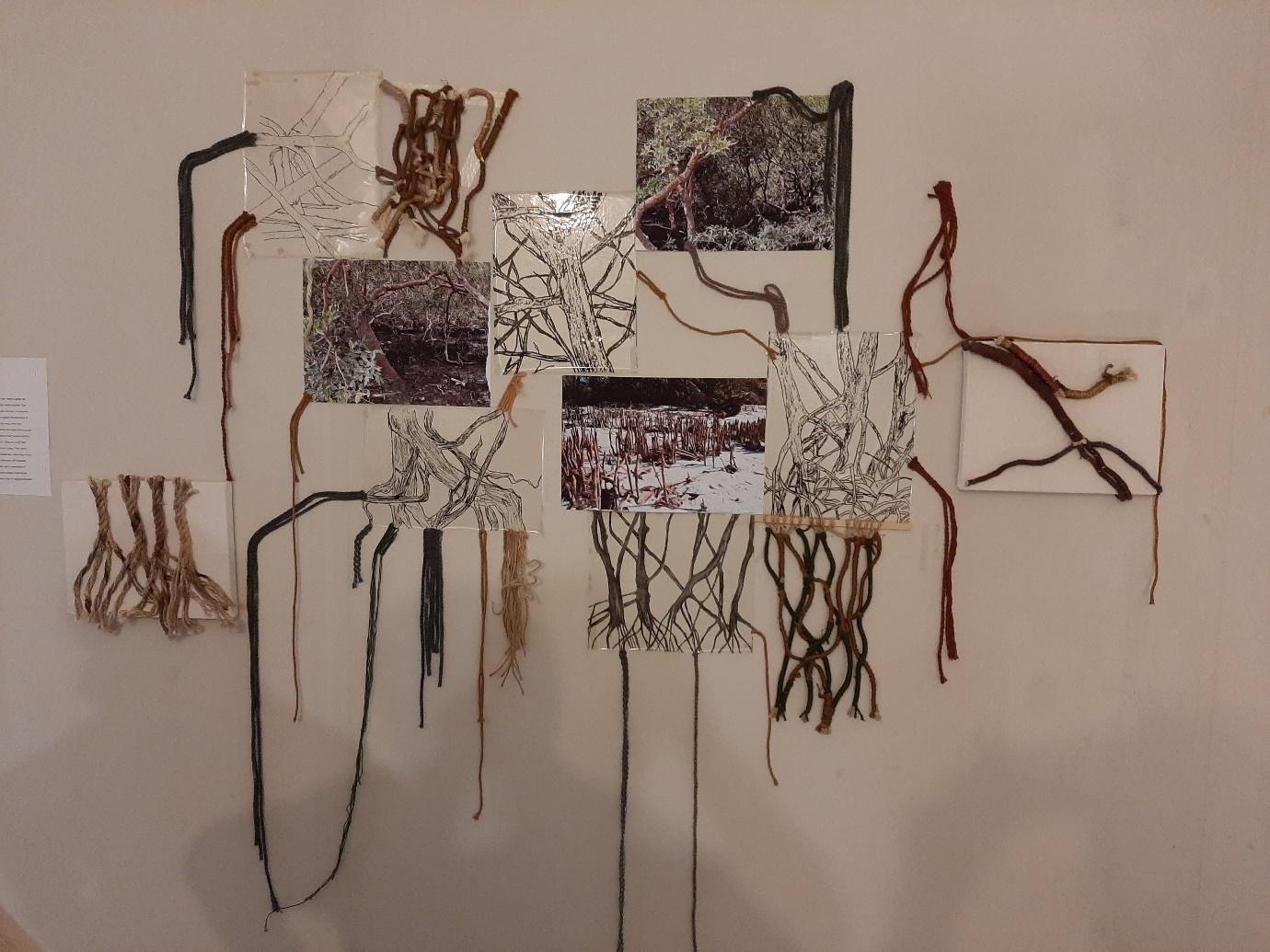
Magical Mangroves: Harbouring coastal biodiversity, guarding communities, enhancing climate resilience and acting as carbon sinks
These enigmatic and thriving ecosystems stand as vital custodians in protecting our planet's ecological harmony. Within Pakistan, these precious coastal forests face imminent threats—from deforestation to burgeoning urban sprawls, limited freshwater flow and silt, and increasing pollution—threatening not just the environment but the lives and livelihoods of coastal communities.
At the forefront, mangroves serve as nature's bulwark against rising sea levels and the ferocity of storm surges, direct consequences of a changing climate. These resilient trees, with their intricate root systems, act as a shield that safeguards coastal settlements from the perilous effects of swelling seas, thereby mitigating the risks of inundation and coastal erosion.
Moreover, mangroves are carbon storehouses, absorbing significant volumes of carbon dioxide from the atmosphere.
Beyond their ecological prowess, mangroves are life nurturers for Pakistan's aquatic coastal communities. They provide sanctuaries for a myriad of fish and crustacean species, serving as pivotal breeding grounds for commercially valuable fish stocks. The vitality of these ecosystems is intrinsically linked to the sustenance and food security of countless families along the coast.
Artistic Tribute: Threads of harmony reflecting mangrove essence
WWF believes in the power of the artistic message. Artwork and installations can transmit connections that inspire and educate. With this view, WWF-Pakistan recently collaborated with the Indus Valley School of Art and Architecture, Karachi, to facilitate a final-year student’s project on mangrove awareness and conservation using textiles.
"Threads of Harmony: Mangroves" is a vibrant tapestry that weaves together art, nature and science, and encapsulates the essence of these coastal sentinels. Nestled between land and sea, these mangroves weave intricate tales of resilience, biodiversity, and environmental harmony. This artistic venture draws attention to the intricacies and nuances of these coastal ecosystems, accentuating the deep connection between them and the planet's overall well-being.
Underneath the verdant canopies of mangroves thrives a bustling and vibrant ecosystem. A multitude of fish and crustaceans find refuge amidst the intricate labyrinth of roots, while migratory birds make vital stopovers during their long journeys. The nutrient-rich waters provide sanctuary for juvenile marine life, significantly contributing to the vigour of oceanic ecosystems.
This art form uses cotton ropes and jute threads to bring nature’s design to light; the submerged ballet of mangrove roots; with diverse root forms from stilt-like structures to intricate tangles. Off-loom weaving was used, entwining threads around a wooden frame using jute ropes as a vertical warp. Various knotting, coiling and macramé techniques, coupled with the subdued, earthy and muted tones that draw from the natural aesthetics of mangrove roots, create a harmonious visual that complements the organic forms within the installation.
The installation, generously donated to WWF-Pakistan, is currently housed at the organization’s Wetland Information Centre at Hawks Bay, Karachi, and is open to the public for viewing.
Together for Conservation: A call to action for a critical ecosystem
Thriving mangrove ecosystems are an effective and critical arsenal in our fight against climate change. Since 2006, WWF-Pakistan has worked with the Government and partners to curb the exploitation of mangroves in the Indus Delta, restoring a remarkable 16,000 hectares and reviving fisheries by restocking 4 million fish eggs. These endeavours raise awareness about mangroves and their management, offer crucial alternatives to grazing and fuelwood, enhance socio-economic resilience and empower local communities, and improve ecological revival.
However, maintaining this success requires concerted action, including fortifying legal protections for mangrove ecosystems, implementing sustainable forestry practices, balancing local needs with conservation efforts, educating and raising public awareness about mangroves, collaborating with conservation organizations and experts for effective short-term and long-term strategies, and engaging in monitoring and research to better understand climate change impacts on mangroves and their ecosystems.
Written by: Shoaib Abdul Razzaque, Coordinator Marine Programme, WWF-Pakistan and Urooba Latifi, Final year student, Indus Valley School.

The breathtaking vastness of our oceans hides a world of wonders, with cetaceans like the awe-inspiring blue whale commanding attention. These majestic creatures, spanning up to 33.6 meters (110 feet) in length and weighing a colossal 190 tonnes, belong to a family encompassing whales, dolphins, and porpoises. Sadly, human-induced activities cast a shadow over these charismatic giants, declining their populations and threatening the vibrancy of our oceans.
Understanding the Importance of Cetaceans
Cetaceans, the unsung heroes in the fight against climate change, play a pivotal role by sequestering carbon in their bodies and transferring it to the ocean floor upon their demise. A single whale can store an impressive 33 tonnes of CO2, surpassing the annual absorption rate of a tree by far. Their presence helps maintain the balance in marine ecosystems as top predators, preventing disruptions in the food chain. Moreover, their biological processes, such as the 'Whale Pump,' release essential nutrients into the water, nurturing the foundation of marine life, the phytoplankton.
Facing Challenges and Threats
Despite their ecological significance, the International Union for Conservation of Nature (IUCN) paints a grim picture, with numerous cetacean species classified as endangered or vulnerable. Threats loom large, from ingesting microplastic or entangled in fishing nets at ocean surface water leading to mortality and injuries, from boat strikes and ocean noise pollution disrupting their communication to climate-induced changes in prey distribution and habitat destruction due to human activities.
The Grim Reality of Bycatch in Pakistan
In Pakistan's waters, bycatch, especially in gillnets, poses a significant threat to cetaceans. Reports reveal the entanglement of species such as the Indo-Pacific humpback dolphins and black finless porpoises, often leading to fatalities. Moreover, incidents of whales like the Blue and Bryde’s whales and various beaked whales getting ensnared have surfaced, raising alarms about the species' vulnerability; 1-4 dolphins were enmeshed in each fishing trip of tuna gillnet fisheries in 2013, which turned to almost zero by 2018 resulted in the shift in fishing gear settings, which is a success. Yet again, the scale of bycatch of cetaceans in gillnet coastal fisheries is still uncertain.
A Cultural Stance and Path to Mitigation
While Pakistan prohibits the consumption of cetaceans, past practices like harpooning dolphins and porpoises for traditional purposes linger in memory. Yet, the positive efforts of fishermen in rescuing entangled species demonstrate a shared commitment to marine conservation.
Mitigating Bycatch and Promoting Conservation
Addressing bycatch involves raising awareness, implementing monitoring protocols, and encouraging behavioral shifts in fishing practices, integrating tools like Acoustic Deterrent Devices (ADDs) and electronic monitoring aids in minimizing bycatch. Moreover, sensitizing fishing communities towards safe handling and reporting of bycatch is pivotal for successful conservation efforts.
WWF-Pakistan’s Contribution to Cetacean Conservation
WWF-Pakistan is at the forefront of cetacean conservation, conducting comprehensive surveys, engaging with fishing communities, and advocating for protecting Important Marine Mammal Areas (IMMAs) in Pakistan's waters. Their collaborative efforts aim to raise awareness, gather critical data, and adopt conservation-friendly practices to secure the future of these magnificent marine species.
Moving Towards a Shared Future
The urgency to protect cetaceans demands collective action. By embracing sustainable fishing practices, prioritizing conservation efforts, and supporting communities dependent on marine resources, we can safeguard the survival of these endangered species. WWF-Pakistan’s relentless dedication is a beacon of hope, emphasizing the need for concerted efforts to protect Pakistan's marine biodiversity and sustain healthy oceans.
Written by Shoaib Abdul Razzaque, Coordinator Marine Programme, WWF-Pakistan.
Imagine cities that value every drop of water. Imagine cities where rain is not just an extreme weather phenomenon but a resource to be cherished. Imagine cities that work efficiently towards reducing their burden on traditional water sources. Such cities play a pivotal role, not just in responsible water consumption, but also in inspiring residents to adopt water sensitive practices - a profound yet simple concept which lies at the heart of sustainable urban development.
Cities with their water-sensitive elements are more than just dots on a map, they are vibrant, pulsating centers of life. They are the crucibles of development. Yet, amidst their dynamism, cities face challenges, such as rapid urbanization that ensue environmental woes – the biggest of which is water scarcity. In an article by Nature, Chunyang He discussed how urban areas are facing an alarming decline in water resources, making it imperative for us to rethink how we manage this precious resource.
Internationally, cities like Melbourne, Australia, and Tokyo, Japan, have implemented innovative water conservation strategies, setting the stage for a global movement towards water-sensitive urban planning. According to Dr. Anna Hurliman, an Associate Professor at University of Melbourne, integrating sustainable urban water management into the very fabric of our cities not only equips us to face these challenges head-on but also paves the way for a harmonious coexistence with nature. By doing so, we are not only securing a sustainable oasis for our present but also for the generations that will follow.
Pakistan is experiencing a strain on its water resources due to mismanagement, high demand, and depleting underground sources. The per capita availability of freshwater has drastically declined over the years, indicating a pressing issue in water resource management. According to Waseem Ishaque, Director Area Study Centre, NUML, Islamabad, the population growth in Pakistan, is expected to reach 250 million by 2025, further exacerbating the problem, leading to a projected decrease in per capita water availability. He stated that Pakistan had a per capita water availability of 5,000 m3 in 1951, which fell to 1,100 m3 in 2005, and by 2025, it is expected to fall to 800 m3.
Taking the importance of sustainable urban water management into account, WWF-Pakistan under the Australia-Pakistan Water Security Initiative (APWASI) is pioneering a transformative change, in the heart of Pakistan. This initiative embodies the spirit of water sensitivity in two underprivileged communities of James Town, Rawalpindi, and Farash Town, Islamabad. Through rainwater harvesting systems, filtration units, ablution water (greywater) reuse systems, recharge interventions and green spaces that capture and harvest rainwater, APWASI is striving for regular water supply and conservation within this urban landscape.
Implementing these initiatives was not devoid of challenges. From initial resistance to adapting to new technologies, communities faced hurdles. To overcome these challenges successfully, WWF-Pakistan has prioritized community engagement and education. This has been achieved through the establishment of community-based organizations (CBOs) and village organizations (VOs), coupled with regular monthly sessions of the community members, dedicated to raising awareness and fostering community participation. Also, for various decision-makings and discussions, Focused Group Discussion (FGDs), CBO and VO meetings, collaborate and co-lead sessions, co-design sessions, information and consultation sessions, and key informant interviews are conducted regularly. This strategic approach not only helps to overcome the challenges related to community involvement but also empowers individuals, fostering a sense of ownership and unity within these neighborhoods.
Looking ahead, it’s crucial for cities worldwide to adopt similar water-sensitive practices. Government policies need to be drafted or revised to encourage and incentivize businesses and residents alike. Innovations in water purification and harvesting technologies are on the horizon, promising even more sustainable solutions.
As residents, we play a crucial role. Simple changes in daily habits, such as fixing leaks promptly or installing water-efficient appliances, can make a significant impact. Getting involved in local community initiatives, supporting policies that promote water conservation, and spreading awareness are key to this. The collective efforts of individuals can transform our cities into thriving, water-sensitive havens.
Embracing water sensitivity isn't merely a choice, it’s a necessity. It’s about reimagining and rethinking our cities, making them not just sustainable but livable and resilient communities where every drop counts. The journey begins with awareness, education, and most importantly, action. Let’s make our cities the pioneers of a water-sensitive future, where water is not just a resource but a lifeline, cherished by all.
By Maryam Eqan, Officer Water Sensitive Cities and Farah Nadeem, Manager Water Security, WWF-Pakistan

The extensive conversion of vegetation into concrete has spurred the increase of the land surface temperature of the city. Several research findings reveal that there has been a rising trend in both the minimum and maximum temperatures during the coldest and warmest months in the Lahore district. These rising temperatures have also created an increase in the demand for electricity for cooling and air conditioning, as well as more frequent urban heat island effect events in the city.
The increasing construction of impervious surfaces such as roads, buildings and other infrastructure over open spaces and natural drains is causing soil sealing, which refers to changes in the nature of the soil such that it behaves as an impermeable medium, often resulting in flooding due to the reduced absorption of rainwater. In recent years, heavy rainfall events have caused significant flooding in the city, disrupting daily life, damaging property and infrastructure, and posing a threat to public health and safety.
Further, this swift increase in population and built-up area has impacted the water table and water quality of Lahore. Impervious surfaces reduce the amount of water that can infiltrate into the ground.
Consequently, more rainwater runs off into stormwater drains and rivers and streams, rather than replenishing groundwater resources. According to the Water and Sanitation Agency’s (WASA) records, the availability of drinkable groundwater in Lahore has significantly decreased over the years. Water which was accessible at a depth of 200 feet in 1980 now requires a depth of at least 800 feet (Express Tribune March 25, 2022). Research has also revealed that 24 per cent of Lahore’s residents are consuming contaminated water with arsenic, exposing them to grave health hazards (Express Tribune November, 2020).
Construction activities, which have risen dramatically in Lahore city in recent years, are also considered the third most significant contributor to the region’s notorious air pollution. According to an annual global survey by a Swiss manufacturer of air purifiers, Lahore has jumped more than 10 places to become the city with the worst air quality in the world in 2022.
To address these issues, and make Lahore a more sustainable and livable city, a multi-faceted and comprehensive approach is required. Urban planners and policymakers must adopt strategies such as strict land-use regulations to protect agricultural land and green spaces, promote green infrastructure, and enhance urban drainage systems.
Furthermore, advanced tools and technologies especially remote sensing and GIS should be used, as these are extremely helpful to regularly measure and spatially monitor urban growth patterns and land use change to identify areas under high urban expansion pressure and assess the impact of urbanization on natural resources.
By Muhammad Asif, Coordinator GIS and Somia Asim, GIS Officer, Richard Garstang Conservation GIS Lab, WWF-Pakistan
Lahore can most certainly be referred to as the cultural hub of Pakistan. The city is famous for its historical gardens, gates, the ‘Walled City’. A bird’s eye view of Lahore would most certainly be a mosaic art piece where centuries old infrastructure is smoothly blending in with more recently constructed buildings. However, Lahore today has its fair share of challenges as well and one such challenge is an exponential growth in its population. In-fact, as per the Government of Pakistan’s finance division, Lahore had a population of slightly over five million in 1998 which then exponentially increased to over 11 million in 2017 [2]. That’s a remarkable increase of 116.3 per cent in population which cannot be considered as sustainable growth over a span of two decades. This rapid increase in population is putting a huge stress on the limits of the city to satisfy food, energy, water and transport needs for its residents. However, with much needed positive steps in the right direction, we can sustainably satisfy the basic needs of a rapidly increasing population in Lahore city.
Tapping into Solar Power Generation
World Bank Group says if we would use just 0.071 per cent of Pakistan’s geographical area for solar PV installation and power generation, we can easily satisfy an existing electricity demand in the country [3]. As a city, Lahore has an annual photovoltaic electricity production of 1411 KWh/kWp which is still incredibly high. Thus, electricity production in Lahore through solar PV systems can facilitate Pakistan in reducing its electricity shortfall during peak hours [4]. Now imagine a scenario where households in Lahore would be able to purchase excellent quality solar PV panels manufactured in Europe, North America and China at an affordable price. There is a dire need that households in the city have the much-needed prior knowledge regarding quality solar PV panels that would last for a long period of time and thus yield higher profit on every rupee invested in purchasing a solar PV system. It is important to point out here that households in Pakistan pay keen attention to pricing of solar PV system [5]. Thus, if the government would somehow ensure that consumers would buy an excellent quality solar PV system at an inexpensive price that can be paid back in 10 years’ time frame, it can really help in maturing rooftop solar PV system technology in Pakistan.
The population of Lahore would most likely be over 22 million by 2050. Now, assuming that five million households in Lahore choose to install a two kilowatt capacity of solar PV system on their roof tops, that would mean 10 million kilowatts of installed roof top solar PV capacity. In terms of gigawatts, it would be a staggering 10 GWs of solar PV capacity. By doing so, we can transform rooftops in Lahore city into small engines of power generation that can mature rooftop solar PV system technology, increase the share of renewable energy and reduce greenhouse gases emission.
Modernizing farming
The government must also focus on swiftly increasing Lahore’s ability to satisfy food demand of its rapidly increasing population. Vertical hydroponic farming is a solution that can really help Lahore city in sustainably utilizing its available resources and thus enhancing its food security. Last year Dubai inaugurated the world’s largest vertical hydroponic farm with an ability to produce one million kilograms of leafy greens on a yearly basis. This vertical hydroponic farm comes in with a price tag of USD 40 million and it uses 95 per cent less water than conventional methods of farming [6]. If Dubai can make it happen, so can Lahore as well. It is important to point out here that traders in Lahore paid 38.57 billion rupees as tax on annual basis from 58 different markets across the city [7]. At the current exchange rate, 38.57 billion rupees would roughly be USD 133 million. The provincial government can use less than one-third of this generated revenue to establish one vertical hydroponic farm in the city. In-fact, Government of Punjab can create a vertical hydroponic industrial area in Lahore city that would have 10 vertical hydroponic farms with an ability to produce 10 million kilograms of leafy greens each year. A 10-year plan where each year the Government of Punjab would establish one vertical hydroponic farm in vertical hydroponic industrial area is realistic and achievable. By doing so, Lahore city would produce 10 million kilograms of leafy greens on annual basis within 10 to 15 years. Most importantly, all this food would be produced with 95 per cent less water than conventional methods of farming.
Greening the city’s landscape
We cannot leave forests out of equation when it comes to promoting Sustainable Development in Lahore. It is pertinent for Government of Punjab to increase the forest cover in Lahore city. An excellent strategy is to plant trees within city and in its outskirts. No doubt Mall Road is one of the most beautiful roads in the city. In my opinion, the primary reason is the planation of trees on its both sides. Likewise, every road in Lahore can have trees on its both sides. If we can plant trees on Mall Road, we can repeat the same process on every other road in the city.
The length of main and link roads in Lahore city is almost 14,069 kilometres. Similarly, the length of local roads, secondary and primary roads are 12,391 kilometres, 1,217 kilometres and 358 kilometres [8]. Altogether, the total length of roads in Lahore is roughly 28,035 kilometres. Now, if we will plant 350 trees per kilometre on both sides of each road in Lahore city. We can exponentially increase the within city forest cover by over 9.8 million trees. A plantation of 350 trees per kilometre is realistic provided enough policy attention and financial resources are invested in this direction.
Now, imagine that we plant another 2.2 million trees in the outskirts of the city that would encircle Lahore like a ring. Altogether, these 12 million trees would increase the biodiversity, reduce air and noise pollution, increase the rainfall, decrease the surface temperature and promote less use of air-conditioning for cooling in the city [9]. We must understand that trees are a nature-based solution to capture and store carbon dioxide gas from atmosphere. Most importantly, trees are home to birds and insects that plays a vital role when it comes to offering crucial ecosystem products and services.
All the solutions presented here are realistic and possible provided enough policy attention and financial resources are channelized in the right direction. India had an installed solar PV capacity of over 63 GWs at the end of 2022 [10]. Likewise, if Dubai can inaugurate a vertical hydroponic farm, so can Lahore city too. The choice is ours and will always be.
Written by Ayoub Hameedi, Stockholm based policy analyst and founder / Operations Manager of Project Green Earth (www.projectge.org).

Mangroves, those resilient salt-tolerant plants found in tropical and subtropical regions, offer a myriad of ecological and socio-economic benefits. However, these vital ecosystems face grave threats from human-induced activities and environmental factors, putting their very existence at risk. To counter these challenges and ensure the conservation of mangroves, innovative technological tools have become crucial in monitoring and safeguarding their growth and health.
Efforts such as reforestation and improved management play a critical role in protecting these precious ecosystems. To safeguard the existence of these ecosystems, WWF-Pakistan has been proactive since 1994; collaborating with the Sindh Forest Department, partner organizations, and local communities to initiate various mangrove plantation drives in the Indus Delta.
In addition to reforestation efforts, the effective monitoring of plantations is important for progress assessment, identification of challenges, and making informed decisions. Although satellite imagery is commonly used for monitoring mangroves and tracking progress, it may lack necessary detail required to accurately detect small-scale plantation seedlings. Some very high-resolution commercial satellites can provide imagery for monitoring saplings, however, the cost associated with accessing this data can be quite prohibitive. While traditional methods of monitoring mangroves have proven helpful, they often lack the precision and detail needed for an accurate assessment. Here's where cutting-edge technological tools are revolutionizing conservation efforts, emerging as an indispensable tool that offers a unique perspective into the growth, health, and progress of mangrove plantations.
Among these, fixed-point photography provides an effective, user-friendly and inexpensive solution to monitor a landscape or any intervention by capturing photographs from the same location before, during or after a project. It is widely utilized for monitoring small-scale ecological changes in protected areas worldwide. Fixed-point photography is a way of taking a photograph from exactly the same spot with consistent camera adjustments including focal length, height and bearing angle during each subsequent visit, so to see changes over time. To conduct accurate and consistent fixed-point photography, a diverse set of tools and equipment is essential, including survey maps, GPS devices, a camera, tripod, gimbal head, fish plate, compass, measuring tape, and data recording forms. During the initial stages, survey maps are used to establish reference points and determine the precise positions for capturing photographs from consistent locations during subsequent visits. Additionally, a handheld GPS is used to navigate to each fixed point and record accurate geographic coordinates.
To capture detailed photographs, it is imperative to have a high-resolution digital camera equipped with a suitable lens. In order to capture photographs without the risk of motion blur, the camera is mounted on a tripod with a gimbal that ensures stability and minimizes camera shake. A compass is used to adjust the camera direction by recording the bearing angle to ensure the same orientation for each snapshot on successive visits. The compass is positioned on the fish plate to determine the angle of direction accurately. The measuring tape is also used to adjust the camera's height, ensuring that photographs are taken from the same height from a reference point or ground level. Additionally, data recording forms are essential to document information including geographic coordinates, date and time, nearby localities, and any additional observations or measurements made during each repeating visit. Based on the observations, recorded on data forms and visualization of the captured photographs, the summary of the monitoring visits is developed which helps the project team to assess the progress and challenges and implement modified strategies to make the project activity successful. This technique offers valuable insights for a variety of applications, including forest plantations and landscape monitoring, land use planning, and conservation efforts.
Established in 2001, the Richard Garstang Conservation GIS Lab at WWF-Pakistan, is a pioneer state-of-the-art GIS lab that plays a vital role in conserving nature through effective assessment and monitoring of natural resources using advanced geospatial tools and techniques. For the past two decades, the lab has been actively monitoring mangrove plantations by integrating remote sensing, GIS tools and fixed-point photography. The lab has conducted extensive fixed-point photography surveys to capture the repeated photographs of saplings to monitor the growth, health and progress of mangrove plantations over the years. WWF-Pakistan's pioneering efforts in integrating fixed-point photography with remote sensing and GIS tools have yielded remarkable results.
By consistently monitoring mangrove plantations using this innovative approach, between 2000 and 2023, Pakistan recorded a remarkable feat, expanding its mangrove cover by approximately 15,000 hectares. This achievement sets Pakistan apart as the sole Southeast Asian country to achieve such a milestone in mangrove conservation.
Observations and findings derived through these surveys have helped the project team to adapt and modify strategies including planting techniques, selecting appropriate species or implementing additional measures to enhance the resilience of mangrove ecosystems through new plantations. Furthermore, the sequential photographs captured during the subsequent visits showcase the success of the transformation of degraded areas into thriving mangrove ecosystems. The photographs not only provide visual evidence of the effectiveness of any intervention but also serve as a source of inspiration for further conservation initiatives. Photographs captured during the fixed-point photography survey comprehensively portray the success story of WWF-Pakistan’s mangrove plantations.
As we navigate the challenges of preserving our precious mangroves, one thing is clear - technological tools have become our allies in the fight against deforestation and degradation. With its cost-effectiveness, ease of use, and valuable insights, fixed-point photography is proving to be a powerful weapon in the conservation arsenal. By embracing these advancements and continuously refining our approach, we can secure a brighter future for mangrove ecosystems and the communities that rely on their invaluable services.


Written by Muhammad Asif, Coordinator GIS, WWF-Pakistan

Abdullah, a 48-year old conservationist and member of the Kakapir fishing community, first became involved in marine turtle conservation at the tender age of 12, when he volunteered to work with a relative of his employed by the Sindh Wildlife Department.
Recounting those early days, Abdullah says, “I would keep a lookout for adult Green turtles and collect their eggs, moving them to a hatchery.”
Actively engaged in the voluntary monitoring and conservation of Green turtles nesting sites in the Hawks Bay area since the 1970s, Abdullah has many stories to share.
“Sometimes, the adult female turtles veer away from their intended nesting grounds. When this happens, I rally community members, and together we locate and rescue the disoriented turtles.”
“I rescue the disoriented turtles by wrapping them in Ajrak (a traditional block-printed shawl) to ensure their safety and release them back into the water. This has to be done cautiously to avoid harm or disturbance.”
Individuals like Abdullah, who actively participate in fishing and community welfare, and dedicate a substantial amount of their time personally monitoring and protecting sea turtles, can offer a solution to conservation organizations in effectively safeguarding vulnerable species by forming a robust and consistent beach monitoring mechanism.
“I have witnessed events where dogs actively excavate the nests to prey on the submerged hatchlings. But these turtles face many other threats too. Development on the beachfront and the waste left behind by beach goers, including disposable plastics, and discarded fishing lines and nets are all obstacles for these turtles and their hatchlings.”, says Abdullah as he sheds light on the many threats and dangers to sea turtles.
“I once witnessed five dogs barking at a nest located across the WWF Wetland Centre. I dug the nest and found around 70 to 80 hatchlings entangled in a ghost net, which was obstructing their exit from the nest and preventing them from reaching the ocean.”
“I released them into the sea during low tide at night” he added proudly.
The traditional knowledge and cultural practices of Abdullah and his community offer an opportunity to strengthen marine turtle conservation efforts. Recognizing the significance of these turtles in the communities’ historical narratives, rituals, and beliefs; Abdullah, and many others like him, have a deep reverence for the species and demonstrate responsibility towards their protection. They have an intimate understanding of nesting behaviour in turtles, which can be tapped to monitor and safeguard these habitats and deter poaching. These communities can effectively act as custodians.
Residing close to the nesting grounds of marine turtles and actively involved in fishing activities, these coastal communities are a key stakeholder and indispensable partners when it comes to marine conservation. By shifting to sustainable fishing practices, including responsible fishing techniques and by participating in the safe handling and release of accidental catches, these communities can make significant contributions to reducing the mortality of marine turtles, whilst ensuring the sustainability of fish stocks and the overall health of the marine ecosystem.
A vulnerable species
Facing numerous threats to both their aquatic habitats and nesting areas, marine turtles are globally endangered.
Marine turtles lack the ability to retreat into their hard shells for protection, unlike freshwater turtles, making them particularly vulnerable to predation and other hazards. Predation by natural predators, disorientation from artificial lighting, and obstacles on their path to the water pose risks to the hatchlings; whereas adults encounter a variety of dangers including entanglement in fishing gear, collisions with boats and vessels, ingestion of marine debris, pollution in their foraging areas, illegal trade, rising temperatures, etc.
Fundamental link in marine ecosystems
Marine turtles are keystone species that contribute to the overall health and balance of the marine ecosystem. Various species play crucial roles that extend beyond their populations, including the maintenance of underwater vegetation in shallow water, supporting intricate food webs, influencing nutrient availability and productivity in marine ecosystems
Written by Summaiya Abid and Shoaib Abdul Razzaque, WWF-Pakistan